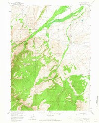
1958 Map of Arlington
USGS Topo · Published 1965About this map
Arlington sits as a central focal point where the historical Overland Trail meets the waters of Rock Creek. This mid-century survey captures a landscape defined by the transition from ranching valleys into the high timber of the Medicine Bow National Forest. The settlement pattern is anchored by several named homesteads and operations, including the Brokaw Ranch, Old Fisher Ranch, and White Ranch, illustrating the distributed rural life of Carbon County during the 1950s.
Find a feature on this map
28 named features on this map. Tap any name to fly to it.
Don’t see what you’re looking for? This feature index may not catch every label — zoom into the map to look around manually.
Map Details
Editions of this 1958 Arlington Map
4 editions found
Other maps of this area

1906 · Medicine Bow
USGS Topo · 1:125,000

1908 · Medicine Bow
USGS Topo · 1:125,000

1954 · Rawlins
USGS Topo · 1:250,000

1958 · Rawlins
USGS Topo · 1:250,000

1958 · White Rock Canyon
USGS Topo · 1:24,000

1958 · Bengough Hill
USGS Topo · 1:24,000

1958 · Arlington
USGS Topo · 1:24,000

1958 · Mc Fadden
USGS Topo · 1:24,000
1958 · Pierce Reservoir
USGS Topo · 1:24,000

1958 · T L Ranch
USGS Topo · 1:24,000