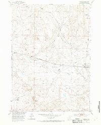
1952 Map of Arminto
USGS Topo · Published 1969About this map
Arminto serves as the focal point for this Natrona County landscape, situated along the tracks of the Chicago Burlington and Quincy railroad. The map depicts a rugged high-plains environment defined by essential water management, featuring various ditches, pipe lines, and storage sites like Jackpot Reservoir and Garrison Reservoir. These features, alongside the Carlson Ranch, highlight the infrastructure required for livestock and human survival in an arid region. Local geography is shaped by drainage systems such as Alkali Creek and Garrison Draw. Significant local markers for genealogists and historians include a small Cem and a rail-side Water Tank near the settlement center. The transportation network is anchored by the Lost Cabin Arminto Road, reflecting the area's role as a transit point between isolated Wyoming ranches and the rail line.
Find a feature on this map
19 named features on this map. Tap any name to fly to it.
Don’t see what you’re looking for? This feature index may not catch every label — zoom into the map to look around manually.
Map Details
Editions of this 1952 Arminto Map
3 editions found
Other maps of this area

1952 · Deadman Butte
USGS Topo · 1:24,000

1952 · Badwater
USGS Topo · 1:24,000

1952 · Arminto
USGS Topo · 1:24,000

1952 · Arminto SW
USGS Topo · 1:24,000

1952 · Arminto NW
USGS Topo · 1:24,000

1952 · Waltman NW
USGS Topo · 1:24,000

1952 · Waltman
USGS Topo · 1:24,000

1952 · Hiland
USGS Topo · 1:24,000

1952 · Badwater SE
USGS Topo · 1:24,000

1955 · Arminto
USGS Topo · 1:250,000