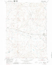
1952 Map of Arminto
USGS Topo · Published 1980About this map
Arminto stands as a rail-dependent settlement in the high plains of Wyoming, positioned where the Chicago Burlington and Quincy railroad cuts across the arid landscape. The town's small footprint is marked by essential infrastructure for the era, including a Water Tank and a local Cem, reflecting its role as a point of habitation in a sparsely populated ranching district. Water management is central to the terrain, with the E-K Ditch and Garrison Reservoir supporting the area's agricultural life. The drainage of Alkali Creek and Garrison Draw creates a complex network of seasonal watercourses that define the ranching boundaries. Further from the town center, the Carlson Ranch and landmarks like VABM Bennet 6298 help orient travelers along the Lost Cabin Arminto Road. This landscape reveals a mid-century reliance on both heavy rail transport and localized irrigation systems to sustain life in Natrona County.
Find a feature on this map
17 named features on this map. Tap any name to fly to it.
Don’t see what you’re looking for? This feature index may not catch every label — zoom into the map to look around manually.
Map Details
Editions of this 1952 Arminto Map
3 editions found
Other maps of this area

1952 · Deadman Butte
USGS Topo · 1:24,000

1952 · Badwater
USGS Topo · 1:24,000

1952 · Arminto
USGS Topo · 1:24,000

1952 · Arminto SW
USGS Topo · 1:24,000

1952 · Arminto NW
USGS Topo · 1:24,000

1952 · Waltman NW
USGS Topo · 1:24,000

1952 · Waltman
USGS Topo · 1:24,000

1952 · Hiland
USGS Topo · 1:24,000

1952 · Badwater SE
USGS Topo · 1:24,000

1955 · Arminto
USGS Topo · 1:250,000