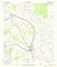
1970 Map of Arnaudville
USGS Topo · Published 1972About this map
Bayou Teche and Bayou Fusilier dominate this South Louisiana landscape, tracing the complex hydrological patterns of the Acadiana region. The town of Arnaudville sits at the convergence of these waterways, straddling the border between St. Landry and St. Martin Parishes. The map reveals a settlement pattern tied closely to the high ground of the natural levees, with long, narrow property lines extending away from the bayous. Transportation and industry are marked by the Missouri Pacific railroad line and various rural landmarks, including the Leonville School and Sacred Heart Chapel near Frozard. In the surrounding wetlands and fields, the emergence of local aquaculture is evidenced by multiple sites labeled Crawfish Farm, alongside older extraction sites like an Oil Well and the community of Pecaniere.
Find a feature on this map
32 named features on this map. Tap any name to fly to it.
Don’t see what you’re looking for? This feature index may not catch every label — zoom into the map to look around manually.
Map Details
Editions of this 1970 Arnaudville Map
2 editions found
Other maps of this area

1939 · Opelousas
USGS Topo · 1:62,500

1940 · Arnaudville
USGS Topo · 1:62,500

1952 · Lake Charles
USGS Topo · 1:250,000

1954 · Lake Charles
USGS Topo · 1:250,000

1954 · Baton Rouge
USGS Topo · 1:250,000

1956 · Opelousas
USGS Topo · 1:62,500

1956 · Baton Rouge
USGS Topo · 1:250,000

1957 · Opelousas
USGS Topo · 1:62,500

1957 · Carencro
USGS Topo · 1:62,500

1959 · Palmetto
USGS Topo · 1:62,500