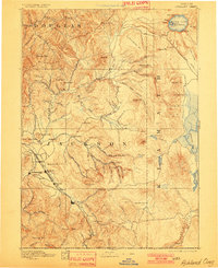
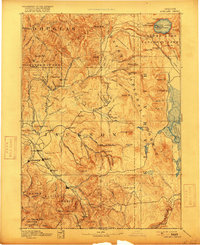
1893 Map of Ashland
USGS Topo · Published 1901About this map
Crater Lake sits at the northern edge of this late 19th-century survey, its depths recorded at 2000 feet alongside Wizard Id. and Llao Rock. The landscape transitions from the volcanic heights of the High Cascades, including the prominent Mt Pitt and Mt Scott, down into the fertile Bear Creek Valley. This valley serves as the primary corridor for settlement and commerce, anchored by the Oregon and California R. R. which connects the towns of Jacksonville, Medford, and Ashland. The presence of numerous named springs, such as Soda Spg. and Soda Spring, highlights the geological character of the region. Local transit and early agriculture are evident in the placement of small communities like Central Point, Phoenix, and Talent, all positioned to take advantage of the river systems feeding the Rogue River.
Find a feature on this map
101 named features on this map. Tap any name to fly to it.
Don’t see what you’re looking for? This feature index may not catch every label — zoom into the map to look around manually.
Map Details
Editions of this 1893 Ashland Map
6 editions found
Other maps of this area

1886 · Modoc Lava Bed
USGS Topo · 1:250,000

1886 · Shasta
USGS Topo · 1:250,000

1889 · Klamath
USGS Topo · 1:250,000

1891 · Ashland
USGS Topo · 1:250,000

1892 · Modoc Lava-Bed
USGS Topo · 1:250,000

1893 · Ashland
USGS Topo · 1:250,000

1894 · Klamath
USGS Topo · 1:250,000

1894 · Shasta
USGS Topo · 1:250,000

1897 · Roseburg
USGS Topo · 1:125,000

1897 · Ashland
USGS Topo · 1:250,000