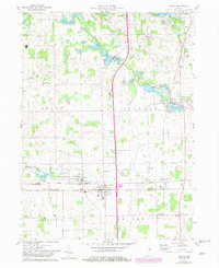
1959 Map of Ashley
USGS Topo · Published 1982About this map
Ashley sits at the junction of the Norfolk And Western railroad and the county line, serving as a focal point for this corner of Northeast Indiana. The landscape is defined by its post-glacial hydrology, with Pigeon Creek and Golden Lake anchoring a complex network of wetlands and drainage ditches like the Johnson Ditch. Small rural communities and crossroad settlements such as Hudson and Steubenville are linked by these rail lines and early highways, with spiritual and social life centered around local landmarks like Mt Zion Ch and St Johns Ch. To the north, the terrain transitions into a lake-rich district near Pleasant Lake, where commercial activities including a Fish Hatchery and Gravel Pit appear alongside recreation areas. The map reveals the slow evolution of the agrarian economy into a more industrial period, marked by the presence of a Gas Well, Oil Well, and widespread utility corridors.
Find a feature on this map
58 named features on this map. Tap any name to fly to it.
Don’t see what you’re looking for? This feature index may not catch every label — zoom into the map to look around manually.
Map Details
Editions of this 1959 Ashley Map
3 editions found
Other maps of this area

1939 · Hamilton
USGS Topo · 1:24,000

1939 · Angola East
USGS Topo · 1:24,000

1940 · Orland
USGS Topo · 1:24,000

1941 · Orland
USGS Topo · 1:24,000

1941 · Angola West
USGS Topo · 1:24,000

1942 · Ashley
USGS Topo · 1:24,000

1942 · Angola West
USGS Topo · 1:24,000

1942 · Stroh
USGS Topo · 1:24,000

1947 · Angola East
USGS Topo · 1:24,000

1948 · Hamilton
USGS Topo · 1:24,000