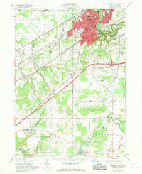
1960 Map of Ashtabula South
USGS Topo · Published 1970About this map
Ashtabula stands as a significant rail and industrial hub near the Lake Erie shoreline, where the Ashtabula River carves a deep valley through the northern landscape. This 1960 era survey reveals a complex transportation network, dominated by the Pennsylvania Line and the New York Chicago and St Louis Line which converge near the city center. The transition from the urban density of Edgewood to the agricultural reaches of Saybrook and Plymouth townships is clearly visible, with several institutions such as Bunker Hill Sch and Windermere Sch serving the growing mid-century community.
Find a feature on this map
49 named features on this map. Tap any name to fly to it.
Don’t see what you’re looking for? This feature index may not catch every label — zoom into the map to look around manually.
Map Details
Editions of this 1960 Ashtabula South Map

Other maps of this area

1905 · Andover
USGS Topo · 1:48,000

1905 · Ashtabula
USGS Topo · 1:62,500

1905 · Jefferson
USGS Topo · 1:62,500

1906 · Conneaut
USGS Topo · 1:62,500

1907 · Andover
USGS Topo · 1:62,500

1907 · Jefferson
USGS Topo · 1:62,500

1950 · Cleveland
USGS Topo · 1:250,000

1956 · Cleveland
USGS Topo · 1:250,000

1959 · Dorset
USGS Topo · 1:24,000

1959 · East Trumbull
USGS Topo · 1:24,000