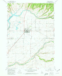
1965 Map of Ashton
USGS Topo · Published 1981About this map
Ashton stands as the central hub of this eastern Idaho landscape, where the agricultural plains of Fremont County meet the rising timber of the Targhee National Forest. The local economy of the mid-1960s is clearly defined by the complex water management system of the Farmers Own Canal and the North Lateral Marysville Canal, which draw from the powerful Henrys Fork and Falls River. Industrial and civic life is anchored by the Union Pacific railroad corridor, the Ashton Fish Hatchery, and the High School. To the north and west, the terrain drops into dramatic breaks like Box Canyon and Putney Canyon, while the Ashton Dam controls the waters of the Ashton Reservoir. This survey documents a vital junction of rail transport, irrigation engineering, and river ecology just before the modern era.
Find a feature on this map
30 named features on this map. Tap any name to fly to it.
Don’t see what you’re looking for? This feature index may not catch every label — zoom into the map to look around manually.
Map Details
Editions of this 1965 Ashton Map
3 editions found
Other maps of this area

1949 · Newdale
USGS Topo · 1:24,000

1950 · Newdale
USGS Topo · 1:24,000

1955 · Ashton
USGS Topo · 1:250,000

1955 · Driggs
USGS Topo · 1:250,000

1958 · Driggs
USGS Topo · 1:250,000

1958 · Ashton
USGS Topo · 1:250,000

1960 · Ashton
USGS Topo · 1:250,000

1962 · Driggs
USGS Topo · 1:250,000

1965 · Lemon Lake
USGS Topo · 1:24,000

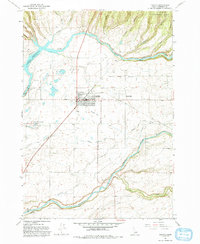
1965 · Ashton
USGS Topo · 1:24,000