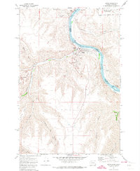
1971 Map of Asotin
USGS Topo · Published 1974About this map
The Snake River carves a deep valley through the borderlands of Washington and Idaho, anchoring the development of Asotin along its western bank. In the early 1970s, this area reflects a mix of civic infrastructure and topographic extremes, from the municipal Sewage Disposal and County Fairgrounds to the steep rise of Maguire Gulch and George Meyer Ridge. The landscape is defined by the sharp transition from the river's edge, marked by Tenmile Rapids, to the high plateaus accessed via Cloverland Road. Outside the primary settlement, smaller locales like Jerry and Clemens sit along the winding course of Asotin Creek. Notable recreational and utility landmarks of the era include the Swallows Nest Golf Club, several Boat Ramps, and the Gun Club near the Lewiston-Nez Perce County Airport.
Find a feature on this map
37 named features on this map. Tap any name to fly to it.
Don’t see what you’re looking for? This feature index may not catch every label — zoom into the map to look around manually.
Map Details
Editions of this 1971 Asotin Map
2 editions found
Other maps of this area

1944 · Anatone
USGS Topo · 1:62,500

1945 · Clarkston
USGS Topo · 1:62,500

1946 · Limekiln Rapids
USGS Topo · 1:62,500

1946 · Anatone
USGS Topo · 1:62,500

1948 · Clarkston
USGS Topo · 1:62,500

1955 · Pullman
USGS Topo · 1:250,000

1958 · Pullman
USGS Topo · 1:250,000

1958 · Lewiston Orchards North
USGS Topo · 1:24,000

1958 · Lewiston Orchards South
USGS Topo · 1:24,000

1958 · Lewiston Orchards
USGS Topo · 1:62,500