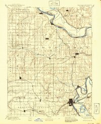
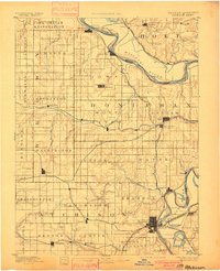
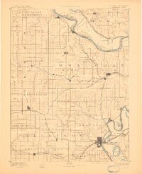
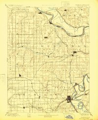
1893 Map of Atchison
USGS Topo · Published 1940About this map
The Iowa Indian Reservation anchors the northern boundary of this late nineteenth-century landscape, where the Missouri River carves a winding path between Kansas and Missouri. The city of Atchison serves as a major regional hub, shown at a time when a dense network of rail lines, including the Missouri Pacific Railroad and the Chicago Kansas and Nebraska Railroad, converged to support the local agricultural economy. Small settlements like Highland, Troy, and White Cloud dot the upland prairies and river bluffs, connected by early routes such as Forbes Road. The drainage patterns are clearly defined by Wolf River and Independence Creek, while the floodplain reveals the oxbow formations of Sugar Lake and Prairie Lake. This survey reflects the transition from frontier settlement to an established rail-and-river trading corridor.
Find a feature on this map
77 named features on this map. Tap any name to fly to it.
Don’t see what you’re looking for? This feature index may not catch every label — zoom into the map to look around manually.
Map Details
Editions of this 1893 Atchison Map
5 editions found
Other maps of this area

1885 · Atchison
USGS Topo · 1:125,000

1886 · Oskaloosa
USGS Topo · 1:125,000

1888 · Oskaloosa
USGS Topo · 1:125,000

1888 · Atchison
USGS Topo · 1:125,000

1888 · Hiawatha
USGS Topo · 1:125,000

1889 · Topeka
USGS Topo · 1:125,000

1890 · Kansas City
USGS Topo · 1:125,000

1893 · Atchison
USGS Topo · 1:125,000

1894 · Kansas City
USGS Topo · 1:125,000

1894 · Oskaloosa
USGS Topo · 1:125,000