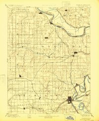
1893 Map of Atchison
USGS Topo · Published 1924About this map
The Missouri River defines the northeastern boundary of this Northeast Kansas landscape, where the Iowa Indian Reservation sits prominently along the northern bluffs near White Cloud. The area's settlement pattern is dictated by a dense network of nineteenth-century railroads, with the Atchison rail hub serving as a primary terminal for lines like the Hannibal and St. Joseph Railroad and the Kansas City St. Joseph and Council Bluffs Railroad.
Find a feature on this map
79 named features on this map. Tap any name to fly to it.
Don’t see what you’re looking for? This feature index may not catch every label — zoom into the map to look around manually.
Map Details
Editions of this 1893 Atchison Map
5 editions found
Other maps of this area

1885 · Atchison
USGS Topo · 1:125,000

1886 · Oskaloosa
USGS Topo · 1:125,000

1888 · Oskaloosa
USGS Topo · 1:125,000

1888 · Atchison
USGS Topo · 1:125,000

1888 · Hiawatha
USGS Topo · 1:125,000

1889 · Topeka
USGS Topo · 1:125,000

1890 · Kansas City
USGS Topo · 1:125,000

1893 · Atchison
USGS Topo · 1:125,000

1894 · Kansas City
USGS Topo · 1:125,000

1894 · Oskaloosa
USGS Topo · 1:125,000