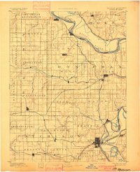
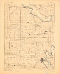
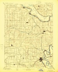
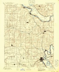
1893 Map of Atchison
USGS Topo · Published 1900About this map
The Iowa Indian Reservation occupies the northern bluffs overlooking the Missouri River in this detailed look at northeast Kansas during the late nineteenth century. This era shows a landscape defined by an intensive network of competing rail lines, including the Missouri Pacific Railroad and the Chicago Kansas and Nebraska Railroad, which spurred the growth of transit hubs like Atchison and Troy. The river's serpentine course is captured here as it was surveyed by the Engineer Corps in 1879, creating complex oxbows and wetlands such as Sugar Lake and Prairie Lake. Inland, the terrain is divided into organized townships like Wolf River and Mission, where small agricultural centers such as Highland, Robinson, and Effingham emerged at critical road and rail junctions. The mapping reveals the proximity of riverfront settlements like Doniphan and White Cloud to the changing shoreline before modern flood control measures.
Find a feature on this map
75 named features on this map. Tap any name to fly to it.
Don’t see what you’re looking for? This feature index may not catch every label — zoom into the map to look around manually.
Map Details
Editions of this 1893 Atchison Map
5 editions found
Other maps of this area

1885 · Atchison
USGS Topo · 1:125,000

1886 · Oskaloosa
USGS Topo · 1:125,000

1888 · Oskaloosa
USGS Topo · 1:125,000

1888 · Atchison
USGS Topo · 1:125,000

1888 · Hiawatha
USGS Topo · 1:125,000

1889 · Topeka
USGS Topo · 1:125,000

1890 · Kansas City
USGS Topo · 1:125,000

1893 · Atchison
USGS Topo · 1:125,000

1894 · Kansas City
USGS Topo · 1:125,000

1894 · Oskaloosa
USGS Topo · 1:125,000