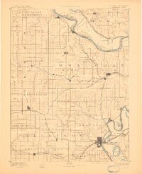
1893 Map of Atchison
USGS Topo · Published 1910About this map
The Missouri River defines the northeastern boundary of this survey, twisting through a wide floodplain where the Iowa Indian Reservation sits at the northern edge of Kansas. This late 19th-century study reveals a landscape dominated by the rapid expansion of the rail system, with nearly a dozen lines crisscrossing the territory to serve agricultural hubs. The city of Atchison emerges as a primary terminus for the Missouri Pacific Railroad and the Atchison Topeka and S. F. R. R., anchoring the region's commerce. Inland, the grid-like township structure is dotted with established settlements like Troy, Highland, and Everest, connected by a network of creeks including Wolf Creek and Stranger Creek. Oxbow formations like Sugar Lake and Prairie Lake near Winthrop reflect the river's historical migration, while the presence of several junctions and branch lines underscores the era's reliance on rail for grain and livestock transport.
Find a feature on this map
79 named features on this map. Tap any name to fly to it.
Don’t see what you’re looking for? This feature index may not catch every label — zoom into the map to look around manually.
Map Details
Editions of this 1893 Atchison Map
5 editions found
Other maps of this area

1885 · Atchison
USGS Topo · 1:125,000

1886 · Oskaloosa
USGS Topo · 1:125,000

1888 · Oskaloosa
USGS Topo · 1:125,000

1888 · Atchison
USGS Topo · 1:125,000

1888 · Hiawatha
USGS Topo · 1:125,000

1889 · Topeka
USGS Topo · 1:125,000

1890 · Kansas City
USGS Topo · 1:125,000

1893 · Atchison
USGS Topo · 1:125,000

1894 · Kansas City
USGS Topo · 1:125,000

1894 · Oskaloosa
USGS Topo · 1:125,000