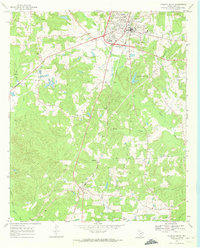
1969 Map of Atlanta South
USGS Topo · Published 1969About this map
Atlanta's southern outskirts and the timber-heavy landscape of Cass County are defined by a mix of early industrial infrastructure and rural community hubs. The Texas and Pacific railroad serves as the primary north-south spine, connecting the regional center of Atlanta to the smaller settlements of Bivins and Huffines near the southern boundary. This era shows a transition toward modern utility and recreational spaces, seen in the development of the Municipal Airport and the private Fin and Feather Club Lake.
Find a feature on this map
24 named features on this map. Tap any name to fly to it.
Don’t see what you’re looking for? This feature index may not catch every label — zoom into the map to look around manually.
Map Details
Editions of this 1969 Atlanta South Map
This is the sole edition of this map. No revisions or reprints were ever made.
Other maps of this area

1907 · Atlanta
USGS Topo · 1:62,500

1910 · Linden
USGS Topo · 1:62,500

1910 · Atlanta
USGS Topo · 1:62,500

1944 · Kildare
USGS Topo · 1:62,500

1948 · Kildare
USGS Topo · 1:62,500

1953 · Texarkana
USGS Topo · 1:250,000

1956 · Texarkana
USGS Topo · 1:250,000

1956 · Tyler
USGS Topo · 1:250,000
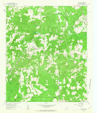
1962 · McLeod
USGS Topo · 1:24,000

1962 · Lanier
USGS Topo · 1:24,000