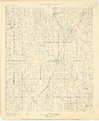
1900 Map of Atoka
USGS Topo · Published 1900About this map
The Chickasaw Nation Choctaw Nation boundary line defines this late-nineteenth-century landscape, a region of Indian Territory where the frontier economy was shifting toward rail-bound industry. The Missouri Kansas and Texas R.R. cuts through the heart of the territory, connecting established coal mining hubs like Lehigh and the regional center at Atoka. This network enabled the growth of settlements that began as isolated outposts or river crossings, such as Davis Ferry on the Clear Boggy Creek and the historic Boggy Depot. Local social foundations are visible through sites like the Chickasaw Rock Academy and Buffalo Creek Church, which served families in the outlying rural districts. The terrain transitions from the lowlands of the Blue River and Muddy Boggy Creek toward landmarks like Black Knob Ridge and Sugarloaf Mt. in the east.
Find a feature on this map
55 named features on this map. Tap any name to fly to it.
Don’t see what you’re looking for? This feature index may not catch every label — zoom into the map to look around manually.
Map Details
Editions of this 1900 Atoka Map
4 editions found
Other maps of this area

1896 · Coalgate
USGS Topo · 1:125,000

1898 · McAlester
USGS Topo · 1:125,000

1899 · Coalgate
USGS Topo · 1:125,000

1899 · Atoka
USGS Topo · 1:125,000

1900 · Atoka
USGS Topo · 1:125,000

1900 · Coalgate
USGS Topo · 1:125,000

1901 · Stonewall
USGS Topo · 1:125,000

1901 · Tishomingo
USGS Topo · 1:125,000

1901 · Antlers
USGS Topo · 1:125,000

1901 · Denison
USGS Topo · 1:125,000