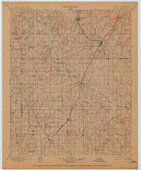
1900 Map of Atoka
USGS Topo · Published 1914About this map
The Choctaw Nation Chickasaw Nation Boundary Line serves as a central axis for this turn-of-the-century landscape, illustrating the administrative divisions of Indian Territory before Oklahoma statehood. Significant tribal institutions like the Chickasaw Rock Academy and another unnamed Academy near Bokchito highlight the early educational infrastructure of the region. The map captures a critical transition in transportation, showing the Missouri Kansas and Texas R.R. connecting industrial hubs like Lehigh and Atoka, while traditional water crossings such as Davis Ferry over Clear Boggy Creek remained vital. Local history is deeply embedded in place names like Old Boggy Depot and Boggy Depot, alongside the colorfully named Robbers Roost. Geologic features such as Black Knob Ridge and the Caddo Hills break the plains, framing a network of waterways including Blue River and Muddy Boggy Creek that dictated the placement of early settlements and churches like Buffalo Creek Church.
Find a feature on this map
53 named features on this map. Tap any name to fly to it.
Don’t see what you’re looking for? This feature index may not catch every label — zoom into the map to look around manually.
Map Details
Editions of this 1900 Atoka Map
4 editions found
Other maps of this area

1896 · Coalgate
USGS Topo · 1:125,000

1898 · McAlester
USGS Topo · 1:125,000

1899 · Coalgate
USGS Topo · 1:125,000

1899 · Atoka
USGS Topo · 1:125,000

1900 · Atoka
USGS Topo · 1:125,000

1900 · Coalgate
USGS Topo · 1:125,000

1901 · Stonewall
USGS Topo · 1:125,000

1901 · Tishomingo
USGS Topo · 1:125,000

1901 · Antlers
USGS Topo · 1:125,000

1901 · Denison
USGS Topo · 1:125,000