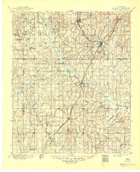
1900 Map of Atoka
USGS Topo · Published 1949About this map
The Chickasaw Nation and Choctaw Nation border line bisects this landscape, marking a significant era of territorial governance in Indian Territory during the late 1890s. The region is defined by the extensive drainage systems of Clear Boggy Creek and Muddy Boggy Creek, which supported early infrastructure like Davis Ferry. Settlements such as Atoka, Lehigh, and Caddo are established along the vital corridor of the Missouri Kansas and Texas RR, illustrating the rail-driven growth that shaped the area's early economy.
Find a feature on this map
45 named features on this map. Tap any name to fly to it.
Don’t see what you’re looking for? This feature index may not catch every label — zoom into the map to look around manually.
Map Details
Editions of this 1900 Atoka Map
4 editions found
Other maps of this area

1896 · Coalgate
USGS Topo · 1:125,000

1898 · McAlester
USGS Topo · 1:125,000

1899 · Coalgate
USGS Topo · 1:125,000

1899 · Atoka
USGS Topo · 1:125,000

1900 · Atoka
USGS Topo · 1:125,000

1900 · Coalgate
USGS Topo · 1:125,000

1901 · Stonewall
USGS Topo · 1:125,000

1901 · Tishomingo
USGS Topo · 1:125,000

1901 · Antlers
USGS Topo · 1:125,000

1901 · Denison
USGS Topo · 1:125,000