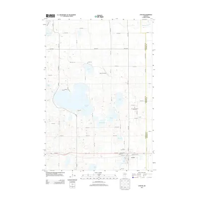
2013 Map of Atwater
USGS Topo · Published 2013About this map
Atwater serves as the primary hub in this portion of Kandiyohi County, situated amidst a dense network of glacial lakes and agricultural land. The settlement's layout is defined by the east-west corridor of US-12 and the local rail line, with several community landmarks including the Bethlehem Cem and the Post Office clustered near the center. The surrounding landscape is dominated by significant water bodies such as Diamond Lake, Wheeler Lake, and Schultz Lake, reflecting the region's post-glacial topography. To the north, the Middle Fork Crow River meanders toward the Meeker County line. This 2013 data provides a clear look at local genealogy sites, from the Saint John's Evangelical Lutheran Cem in the east to the Union Cem south of the main township. Small-scale aviation is represented by Pagel's Field Airport, tucked between Sperry Lake and the various county roads that grid the prairie.
Find a feature on this map
65 named features on this map. Tap any name to fly to it.
Don’t see what you’re looking for? This feature index may not catch every label — zoom into the map to look around manually.
Map Details
Editions of this 2013 Atwater Map
This is the sole edition of this map. No revisions or reprints were ever made.
Other maps of this area

1953 · Saint Cloud
USGS Topo · 1:250,000

1956 · Atwater
USGS Topo · 1:62,500

1957 · Saint Cloud
USGS Topo · 1:250,000

1958 · Saint Cloud
USGS Topo · 1:250,000

1967 · Grove City
USGS Topo · 1:24,000

1967 · Lake Koronis
USGS Topo · 1:24,000
1967 · Rosendale
USGS Topo · 1:24,000

1967 · Hawick
USGS Topo · 1:24,000
1967 · New London
USGS Topo · 1:24,000
1982 · Lake Elizabeth
USGS Topo · 1:24,000