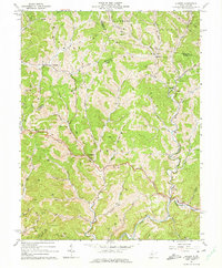
1964 Map of Auburn
USGS Topo · Published 1974About this map
Auburn and Coxs Mills serve as central nodes in this mid-1960s landscape, where the borders of Ritchie, Doddridge, and Gilmer counties converge. The terrain is defined by a dense network of watercourses, including the Right Fork and Horn Creek, which dictate the placement of early settlements and roads. This survey documents an economy heavily reliant on natural resources, evidenced by the numerous Gas Wells and Oil Wells peppered across the ridges and hollows, such as Brake Hollow and Lick Run.
Find a feature on this map
59 named features on this map. Tap any name to fly to it.
Don’t see what you’re looking for? This feature index may not catch every label — zoom into the map to look around manually.
Map Details
Editions of this 1964 Auburn Map
2 editions found
Other maps of this area

1893 · Sutton
USGS Topo · 1:125,000

1904 · Vadis
USGS Topo · 1:62,500

1906 · Holbrook
USGS Topo · 1:62,500

1906 · Glenville
USGS Topo · 1:62,500

1906 · Burnsville
USGS Topo · 1:62,500

1924 · Holbrook
USGS Topo · 1:62,500

1925 · Glenville
USGS Topo · 1:62,500

1925 · Burnsville
USGS Topo · 1:62,500

1925 · Vadis
USGS Topo · 1:62,500

1926 · Holbrook
USGS Topo · 1:62,500