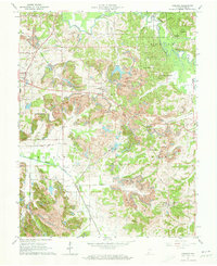
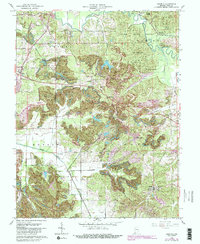
1961 Map of Augusta
USGS Topo · Published 1973About this map
The Indian Treaty Boundary cuts through the southern portion of this Pike County landscape, a historical marker of early settlement limits that still shaped land divisions in the early 1960s. The region is defined by a dense network of extraction and transit, where strip mines and the Blackfoot Mine are juxtaposed with the winding course of the Patoka River. Industrial history is etched into the terrain through the remnants of an Old Railroad Grade and the active lines of the Southern railroad, connecting small settlements like Augusta and Hartwell Junction. Local life is anchored by community landmarks such as St Peters Ch near Stendal and the Odd Fellows Cem, while the Hartwell Lookout Tower stands over the wooded expanses of the Pike County State Forest. The map captures a moment when the coal economy was physically reshaping the geography of Marion, Lockhart, and Monroe townships.
Find a feature on this map
38 named features on this map. Tap any name to fly to it.
Don’t see what you’re looking for? This feature index may not catch every label — zoom into the map to look around manually.
Map Details
Editions of this 1961 Augusta Map
5 editions found
Other maps of this area

1900 · De Gonia Springs
USGS Topo · 1:62,500

1902 · Ditney
USGS Topo · 1:125,000

1902 · Degonia Springs
USGS Topo · 1:62,500

1902 · Boonville
USGS Topo · 1:62,500

1903 · Velpen
USGS Topo · 1:62,500

1903 · Petersburg
USGS Topo · 1:62,500

1956 · Vincennes
USGS Topo · 1:250,000

1957 · Vincennes
USGS Topo · 1:250,000

1958 · Vincennes
USGS Topo · 1:250,000
1960 · Folsomville
USGS Topo · 1:24,000