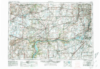
1958 Map of Aurora
USGS Topo · Published 1974About this map
The Illinois River corridor serves as the industrial and natural anchor of this region, winding through a landscape transitioning from the dense urban expansion of western Chicago to the fertile prairie of north-central Illinois. In the east, the rapid growth of Aurora and Naperville is evident as suburban development pushes toward the Du Page River. This 1974 revision, based on surveys dating back to 1916, documents the post-war industrial footprint, most notably the Joliet Arsenal and the concentration of river-side industry in Peru and Ottawa.
Find a feature on this map
167 named features on this map. Tap any name to fly to it.
Don’t see what you’re looking for? This feature index may not catch every label — zoom into the map to look around manually.
Map Details
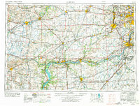
Editions of this 1958 Aurora Map
3 editions found