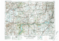
1958 Map of Aurora
USGS Topo · Published 1981About this map
The Illinois River corridor and its industrial-agricultural surroundings define this mid-century portrait of northern Illinois. Heavy rail infrastructure, including the Burlington Northern and Santa Fe lines, crisscrosses the landscape, supporting established manufacturing centers like Aurora, Joliet, and Streator. Cultural and conservation sites are prominent, from Northern Illinois University in De Kalb to the natural landmarks at Starved Rock State Park and White Pines Forest State Park. The map documents a period of rapid suburban expansion along the Illinois Tollway toward the eastern edge, while the southwestern reaches remain dominated by rural river valleys and drainage systems like the Green River and Bureau Creek. This 1958 survey, revised in 1980, captures the area before the full transition of the Joliet Army Ammunition Plant and the expansion of the regional park system.
Find a feature on this map
90 named features on this map. Tap any name to fly to it.
Don’t see what you’re looking for? This feature index may not catch every label — zoom into the map to look around manually.
Map Details
Editions of this 1958 Aurora Map
3 editions found

Other maps of this area

1890 · Des Plaines
USGS Topo · 1:62,500

1891 · Riverside
USGS Topo · 1:62,500

1891 · Clinton
USGS Topo · 1:62,500

1892 · Morris
USGS Topo · 1:62,500

1892 · Marseilles
USGS Topo · 1:62,500

1892 · Joliet
USGS Topo · 1:62,500

1892 · Savanna
USGS Topo · 1:62,500

1892 · Wilmington
USGS Topo · 1:62,500

1892 · Ottawa
USGS Topo · 1:62,500

1893 · Riverside
USGS Topo · 1:62,500