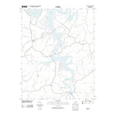
2010 Map of Austin
USGS Topo · Published 2010About this map
Barren River Lake dominates the central landscape of this Barren County survey, its jagged, dendritic shoreline reaching into various creek valleys and defining the modern character of the area. The map illustrates a rural landscape where traditional crossroads like Austin and Cedar Springs exist alongside newer developments oriented toward the water, such as the numerous docks and roads branching off State Park Rd. Evidence of the region’s earlier settlement patterns is preserved in the location of the Austin Cemetery and the many winding routes named for local families, including A G Graves Rd and Noah Steenbergen Rd. Smaller residential clusters like Maynard and Pea Ridge are situated on the higher ground between drainage systems like Walnut Creek and Hurricane Creek, while public access points such as the Walnut Creek Boat Ramp and Browns Ford Boat Ramp highlight the shift toward recreation and conservation in the 21st century.
Find a feature on this map
54 named features on this map. Tap any name to fly to it.
Don’t see what you’re looking for? This feature index may not catch every label — zoom into the map to look around manually.
Map Details
Editions of this 2010 Austin Map
This is the sole edition of this map. No revisions or reprints were ever made.
Other maps of this area

1926 · Scottsville
USGS Topo · 1:62,500

1931 · Lafayette
USGS Topo · 1:62,500

1931 · Red Boiling Springs
USGS Topo · 1:62,500

1953 · Tracy
USGS Topo · 1:24,000

1953 · Glasgow South
USGS Topo · 1:24,000

1954 · Austin
USGS Topo · 1:24,000

1954 · Fountain Run
USGS Topo · 1:24,000

1954 · Petroleum
USGS Topo · 1:24,000

1954 · Scottsville
USGS Topo · 1:24,000
1954 · Meador
USGS Topo · 1:24,000