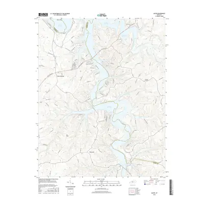
2016 Map of Austin
USGS Topo · Published 2016About this map
The intricate shoreline of Barren River Lake dominates this 2016 survey, where the rising water has transformed the valleys of Peter Creek, Hurricane Creek, and Walnut Creek into a complex series of inlets and coves. This modern landscape is defined by the intersection of the reservoir's fingers with established rural communities. The small settlement of Austin remains a focal point on the eastern side, adjacent to the Austin Cemetery, while Cedar Springs and Maynard anchor the western and southern reaches of the map respectively.
Find a feature on this map
97 named features on this map. Tap any name to fly to it.
Don’t see what you’re looking for? This feature index may not catch every label — zoom into the map to look around manually.
Map Details
Editions of this 2016 Austin Map
This is the sole edition of this map. No revisions or reprints were ever made.
Other maps of this area

1926 · Scottsville
USGS Topo · 1:62,500

1931 · Lafayette
USGS Topo · 1:62,500

1931 · Red Boiling Springs
USGS Topo · 1:62,500

1953 · Tracy
USGS Topo · 1:24,000

1953 · Glasgow South
USGS Topo · 1:24,000

1954 · Austin
USGS Topo · 1:24,000

1954 · Fountain Run
USGS Topo · 1:24,000

1954 · Petroleum
USGS Topo · 1:24,000

1954 · Scottsville
USGS Topo · 1:24,000
1954 · Meador
USGS Topo · 1:24,000