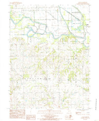
1984 Map of Avalon
USGS Topo · Published 1985About this map
The Grand River meanders across this mid-1980s landscape, defining the northern geography where it meets Medicine Creek and Wolf Grove Creek. This portion of Livingston County is characterized by its complex drainage systems and the serpentine oxbows of the river valley, which include notable water bodies like Custer Lake, Billy Lake, and McKenny Lake. The settlement pattern centers on the village of Avalon in the southern portion of the quadrangle, while the northern edge is marked by the presence of Bedford Station and the tracks of the Norfolk and Western railroad.
Find a feature on this map
21 named features on this map. Tap any name to fly to it.
Don’t see what you’re looking for? This feature index may not catch every label — zoom into the map to look around manually.
Map Details
Editions of this 1984 Avalon Map
This is the sole edition of this map. No revisions or reprints were ever made.
Other maps of this area

1921 · Chillicothe
USGS Topo · 1:62,500

1923 · Chillicothe
USGS Topo · 1:62,500

1924 · Dawn
USGS Topo · 1:62,500

1924 · Chula
USGS Topo · 1:62,500

1924 · Hale
USGS Topo · 1:62,500

1947 · Chula
USGS Topo · 1:62,500

1950 · Coloma
USGS Topo · 1:24,000

1950 · Hale
USGS Topo · 1:24,000

1951 · Hale
USGS Topo · 1:24,000

1951 · Utica
USGS Topo · 1:62,500