
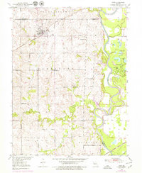
1950 Map of Hale
USGS Topo · Published 1956About this map
The settlement of Hale serves as the primary hub of this north-central Missouri landscape, situated near the intersection of the Chicago Burlington and Quincy railroad and several local arterial routes. The terrain is defined by the winding course of the Grand River, which forms the eastern boundary of Carroll County, creating a complex system of oxbows and backwaters including Wheelbarger Lake, Rampshire Lake, and Grassy Lake. This riverine environment contrasts with the higher ground to the west, where agriculture and rural education were the backbone of the community, evidenced by numerous country schools like Battsville Sch and Compton Sch.
Find a feature on this map
43 named features on this map. Tap any name to fly to it.
Don’t see what you’re looking for? This feature index may not catch every label — zoom into the map to look around manually.
Map Details
Editions of this 1950 Hale Map
2 editions found
Other maps of this area

1890 · Marshall
USGS Topo · 1:125,000

1892 · Marshall
USGS Topo · 1:125,000

1901 · Marshall
USGS Topo · 1:125,000

1924 · Hale
USGS Topo · 1:62,500

1949 · Mendon
USGS Topo · 1:24,000

1949 · Sumner
USGS Topo · 1:24,000

1950 · Sumner
USGS Topo · 1:24,000

1951 · Hale
USGS Topo · 1:24,000

1951 · Bosworth
USGS Topo · 1:24,000

1951 · Brunswick West
USGS Topo · 1:24,000