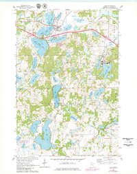
1965 Map of Avon
USGS Topo · Published 1980About this map
Glacial lakes and wetlands define the landscape of Stearns County, where the village of Avon sits nestled between Lower Spunk Lake and Middle Spunk Lake. The area is a mosaic of water and wood, characterized by significant academic and religious sites such as St Johns University and the Stella Maris Chapel situated along the shores of Sagatagan Lake. The presence of the Great Northern railroad corridor highlights the mid-century transportation network that connected these rural townships. South of the main settlement, the terrain transitions into a dense concentration of water bodies including Big Watab Lake and Big Fish Lake, interspersed with designated conservation lands like the National Waterfowl Production Area. These features reveal a community deeply integrated with its natural hydrology, from the small St Johns Cemetery to the remote Timberlee Chapel, reflecting the localized history of the Collegeville and St. Joseph townships.
Find a feature on this map
48 named features on this map. Tap any name to fly to it.
Don’t see what you’re looking for? This feature index may not catch every label — zoom into the map to look around manually.
Map Details
Editions of this 1965 Avon Map
3 editions found
Other maps of this area

1953 · Saint Cloud
USGS Topo · 1:250,000

1957 · Saint Cloud
USGS Topo · 1:250,000

1958 · Saint Cloud
USGS Topo · 1:250,000

1965 · Albany
USGS Topo · 1:24,000

1965 · St Stephen
USGS Topo · 1:24,000

1965 · Farming
USGS Topo · 1:24,000

1965 · Holdingford
USGS Topo · 1:24,000

1965 · St Joseph
USGS Topo · 1:24,000

1965 · Avon
USGS Topo · 1:24,000

1967 · Cold Spring
USGS Topo · 1:24,000