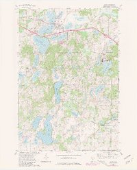
1965 Map of Avon
USGS Topo · Published 1980About this map
Glacial lakes dominate this portion of Stearns County, where the town of Avon sits surrounded by a complex system of water bodies including Lower Spunk Lake and Lake Anna. The landscape is defined by the kettle-and-kame topography common to the region, with numerous smaller basins like Kepper Lake and Achman Lake dotting the terrain. To the south, the sprawling campus of St Johns University occupies the wooded shores of Sagatagan Lake, featuring several religious landmarks such as St Johns Chapel, Stella Maris Chapel, and the St Johns Cem.
Find a feature on this map
50 named features on this map. Tap any name to fly to it.
Don’t see what you’re looking for? This feature index may not catch every label — zoom into the map to look around manually.
Map Details
Editions of this 1965 Avon Map
3 editions found
Other maps of this area

1953 · Saint Cloud
USGS Topo · 1:250,000

1957 · Saint Cloud
USGS Topo · 1:250,000

1958 · Saint Cloud
USGS Topo · 1:250,000

1965 · Albany
USGS Topo · 1:24,000

1965 · St Stephen
USGS Topo · 1:24,000

1965 · Farming
USGS Topo · 1:24,000

1965 · Holdingford
USGS Topo · 1:24,000

1965 · St Joseph
USGS Topo · 1:24,000

1965 · Avon
USGS Topo · 1:24,000

1967 · Cold Spring
USGS Topo · 1:24,000