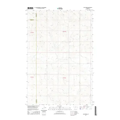
2017 Map of Ayer Spring
USGS Topo · Published 2017About this map
Ayer Spring sits near the intersection of several county lines in this sparsely populated stretch of the eastern Montana prairie. The map documents a landscape defined by its drainage systems, most notably Pennel Cr and its tributaries like Dry-Fork Cr, which carve subtle relief into the terrain. Situated at the juncture where Fallon, Prairie, and Custer counties meet, the area represents a classic high-plains ranching environment. Transportation is limited to a few arterial routes such as Westmore Rd and the crossing of Riley Trl. These primitive roads and seasonal water sources reflect the remote character of this region during the early twenty-first century, providing a clear record of the rural infrastructure and land divisions in a part of the state where few formal settlements exist.
Find a feature on this map
13 named features on this map. Tap any name to fly to it.
Don’t see what you’re looking for? This feature index may not catch every label — zoom into the map to look around manually.
Map Details
Editions of this 2017 Ayer Spring Map
This is the sole edition of this map. No revisions or reprints were ever made.
Other maps of this area

1953 · Miles City
USGS Topo · 1:250,000

1957 · Miles City
USGS Topo · 1:250,000

1958 · Miles City
USGS Topo · 1:250,000

1981 · Baker
USGS Topo · 1:100,000

1981 · Mildred NE
USGS Topo · 1:24,000

1981 · Lawrence Creek West
USGS Topo · 1:24,000
1981 · Ismay North
USGS Topo · 1:24,000

1981 · Dorothy Draw
USGS Topo · 1:24,000

1981 · Ayer Spring NE
USGS Topo · 1:24,000

1981 · Ayer Spring
USGS Topo · 1:24,000