
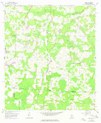
1956 Map of Baden
USGS Topo · Published 1958About this map
Piscola Creek and its tributary Pine Branch define the drainage of this borderland territory in the mid-1950s, where the rural communities of Baden and Empress sit along the Southern railroad line. The map illustrates a landscape transitioned into managed timber and small-scale agriculture, marked by several prominent bay and lake features like Stanley Bay and Sandy Lake.
Find a feature on this map
30 named features on this map. Tap any name to fly to it.
Don’t see what you’re looking for? This feature index may not catch every label — zoom into the map to look around manually.
Map Details
Editions of this 1956 Baden Map
2 editions found
Other maps of this area

1954 · Valdosta
USGS Topo · 1:250,000

1956 · Grooverville
USGS Topo · 1:24,000

1956 · Nankin
USGS Topo · 1:24,000

1958 · Valdosta
USGS Topo · 1:250,000

1959 · Valdosta
USGS Topo · 1:250,000

1960 · Cherry Lake
USGS Topo · 1:24,000

1961 · Quitman
USGS Topo · 1:62,500

1961 · Ousley
USGS Topo · 1:24,000

1962 · Ashville
USGS Topo · 1:24,000
1962 · Hamburg
USGS Topo · 1:24,000