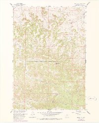
1958 Map of Badger Peak
USGS Topo · Published 1978About this map
The Northern Cheyenne Indian Reservation Boundary bisects this landscape of Rosebud County, Montana, providing a detailed view of the terrain as it appeared during the late 1950s. The southern portion of the map is defined by the high point at Badger Peak and the nearby Skyline Road, which traverses the ridge lines above the drainage basins. Along the southern edge, the small settlement of Alderson sits near Alderson Creek, accompanied by a local Mine and Picnic Grounds, reflecting a mix of small-scale industry and community gathering points in this remote portion of the Missouri River Basin. The complex drainage network of the northern half is shaped by features like Downey Coulee and West Fork Miller Creek, while landmarks such as Charlie Black Butte and Diamond R Spring name specific corners of this high plains landscape.
Find a feature on this map
27 named features on this map. Tap any name to fly to it.
Don’t see what you’re looking for? This feature index may not catch every label — zoom into the map to look around manually.
Map Details
Editions of this 1958 Badger Peak Map
2 editions found
Other maps of this area

1954 · Hardin
USGS Topo · 1:250,000

1957 · Hardin
USGS Topo · 1:250,000

1958 · Hardin
USGS Topo · 1:250,000

1958 · Garfield Peak
USGS Topo · 1:24,000

1958 · Jimtown
USGS Topo · 1:24,000

1958 · Fisher Butte
USGS Topo · 1:24,000

1958 · Lame Deer
USGS Topo · 1:24,000

1958 · Badger Peak
USGS Topo · 1:24,000

1958 · Hollowwood Creek
USGS Topo · 1:24,000

1971 · Colstrip SW
USGS Topo · 1:24,000