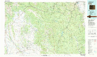
1983 Map of Bailey
USGS Topo · Published 1983About this map
The South Platte River and its numerous forks define the drainage of this high-elevation landscape, where the Kenosha Mountains and Tarryall Mountains dominate the terrain. This 1983 revision captures the transition from wilderness areas like the Mount Evans Wilderness to the increasingly structured Subdivision Road Pattern visible in the lower sections of the map. Major reservoirs, including Cheesman Lake and Antero Reservoir, indicate the critical role of the watershed in supporting regional water needs.
Find a feature on this map
160 named features on this map. Tap any name to fly to it.
Don’t see what you’re looking for? This feature index may not catch every label — zoom into the map to look around manually.
Map Details
Editions of this 1983 Bailey Map
2 editions found
Other maps of this area

1889 · Leadville
USGS Topo · 1:125,000

1890 · East Denver
USGS Topo · 1:125,000

1891 · Leadville
USGS Topo · 1:125,000

1893 · Platte Canyon
USGS Topo · 1:125,000

1893 · Colorado Springs
USGS Topo · 1:125,000

1894 · Pikes Peak
USGS Topo · 1:125,000

1894 · Castle Rock
USGS Topo · 1:125,000

1899 · West Denver
USGS Topo · 1:125,000

1901 · Pikes Peak
USGS Topo · 1:125,000

1901 · Pikes Peak
USGS Topo · 1:62,500