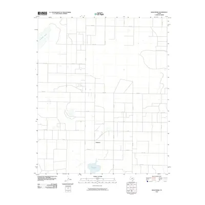
2010 Map of Baileyboro
USGS Topo · Published 2010About this map
Baileyboro sits at the heart of a vast agricultural grid in West Texas, characterized by a network of rural county roads and farm-to-market routes. The landscape is defined by its intermittent water features, most notably the wide expanse of Coyote Lake in the northwestern corner and Baileyboro Lake to the south. These ephemeral basins, typical of the Llano Estacado, punctuate an otherwise orderly system of section lines and irrigation-ready terrain. The map reveals the infrastructure of early 21st-century ranching and farming, with routes like Fm 2487 and Fm 298 providing the primary arteries for this rural community. The dense concentration of named county roads, such as Co Rd 1170 and Co Rd 1181, underscores the importance of accessibility for the scattered homesteads and agricultural operations that sustain the region.
Find a feature on this map
23 named features on this map. Tap any name to fly to it.
Don’t see what you’re looking for? This feature index may not catch every label — zoom into the map to look around manually.
Map Details
Editions of this 2010 Baileyboro Map
This is the sole edition of this map. No revisions or reprints were ever made.
Other maps of this area

1954 · Clovis
USGS Topo · 1:250,000

1954 · Brownfield
USGS Topo · 1:250,000

1958 · Brownfield
USGS Topo · 1:250,000

1958 · Clovis
USGS Topo · 1:250,000

1962 · Brownfield
USGS Topo · 1:250,000

1962 · Muleshoe
USGS Topo · 1:24,000

1962 · Needmore
USGS Topo · 1:24,000

1962 · Stegall
USGS Topo · 1:24,000

1962 · Birdwell Ranch
USGS Topo · 1:24,000

1962 · Baileyboro NE
USGS Topo · 1:24,000