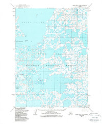
1953 Map of Baird Inlet C-6
USGS Topo · Published 1988About this map
Yukon Delta National Wildlife Refuge landscapes dominate this mid-century survey, revealing a complex hydrological system of tidal flats and braided waterways along the Bering Sea coast. The topography is defined by the massive expanse of Baird Inlet and the eastern edge of Nelson Island, where Kalarvik Pt reaches into the water. Further inland, the drainage patterns of the Kolavinarak River and the Kinaruk River illustrate the slow, winding path of water through the alluvial tundra. These river systems, including the large Kinaruk Lake, reflect a landscape that remained largely unshaped by permanent infrastructure at the time of the 1952 aerial photography, serving as a baseline for the region's natural geography.
Find a feature on this map
7 named features on this map. Tap any name to fly to it.
Don’t see what you’re looking for? This feature index may not catch every label — zoom into the map to look around manually.
Map Details
Editions of this 1953 Baird Inlet C-6 Map
2 editions found
Other maps of this area

1951 · Baird Inlet
USGS Topo · 1:250,000
1953 · Baird Inlet C-5
USGS Topo · 1:63,360

1953 · Baird Inlet D-5
USGS Topo · 1:63,360
1953 · Baird Inlet C-6
USGS Topo · 1:63,360

1953 · Baird Inlet B-5
USGS Topo · 1:63,360

1954 · Baird Inlet D-6
USGS Topo · 1:63,360

1954 · Baird Inlet C-7
USGS Topo · 1:63,360

1954 · Baird Inlet D-7
USGS Topo · 1:63,360

1954 · Baird Inlet
USGS Topo · 1:250,000

1954 · Baird Inlet B-6
USGS Topo · 1:63,360