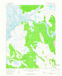
1955 Map of Baird Mountains A-1
USGS Topo · Published 1964About this map
The Kobuk River dominates this mid-century Alaskan landscape, winding through a complex network of wetlands and tributaries. The river's path is defined by sharp bends and oxbows, joined by the Tutuksuk River and Salmon River from the north, and Nigeruk Creek from the south. This area, located within the Kateel River Meridian, shows a wilderness before permanent infrastructure, where the land is characterized by shifting hydrology and the surprising presence of the Great Kobuk Sand Dunes in the southeast. Triangulation stations like VABM 285 Kalig and VABM 353 Nigeruk provided the essential control points for the Geological Survey to map this unsurveyed territory using 1955 aerial photography. The absence of roads or trails emphasizes the reliance on the river systems for movement through the interior during this era.
Find a feature on this map
10 named features on this map. Tap any name to fly to it.
Don’t see what you’re looking for? This feature index may not catch every label — zoom into the map to look around manually.
Map Details
Editions of this 1955 Baird Mountains A-1 Map
3 editions found
Other maps of this area

1951 · Baird Mountains
USGS Topo · 1:250,000

1951 · Selawik
USGS Topo · 1:250,000

1951 · Shungnak
USGS Topo · 1:250,000

1951 · Ambler River
USGS Topo · 1:250,000

1955 · Shungnak
USGS Topo · 1:250,000

1955 · Baird Mountains A-1
USGS Topo · 1:63,360

1955 · Selawik D-2
USGS Topo · 1:63,360

1955 · Ambler River A-6
USGS Topo · 1:63,360

1955 · Shungnak D-6
USGS Topo · 1:63,360

1955 · Baird Mountains A-2
USGS Topo · 1:63,360