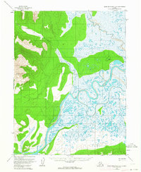
1955 Map of Baird Mountains A-2
USGS Topo · Published 1964About this map
The Kobuk River dominates the lower half of this landscape, its wide channel and braided bars flanked by a solitary Cabin situated on the western bank. This 1955 survey illustrates a wilderness defined by water and altitude, where the northern wetlands of the Salmon River contrast with the high benchmarks of VABM Kiana and VABM Goldie to the west. The river systems here are intricate; smaller tributaries like Trinity Creek and Etaroniluk Creek feed into the main Kobuk artery. These features indicate a seasonal environment where transportation and habitation likely relied on the seasonal rhythm of the river, with Kallarichuk River and Tutiksuk Creek providing further navigational routes through the interior. The mapping reflects the territory's character just before the mid-1960s revisions, preserving the sparse footprint of human presence in the Arctic during the mid-century.
Find a feature on this map
10 named features on this map. Tap any name to fly to it.
Don’t see what you’re looking for? This feature index may not catch every label — zoom into the map to look around manually.
Map Details
Editions of this 1955 Baird Mountains A-2 Map
3 editions found
Other maps of this area

1951 · Baird Mountains
USGS Topo · 1:250,000

1951 · Selawik
USGS Topo · 1:250,000

1955 · Baird Mountains A-1
USGS Topo · 1:63,360

1955 · Selawik D-2
USGS Topo · 1:63,360

1955 · Baird Mountains A-2
USGS Topo · 1:63,360
1955 · Selawik D-1
USGS Topo · 1:63,360

1955 · Selawik D-3
USGS Topo · 1:63,360

1955 · Baird Mountains B-3
USGS Topo · 1:63,360

1955 · Baird Mountains A-3
USGS Topo · 1:63,360

1956 · Baird Mountains
USGS Topo · 1:250,000