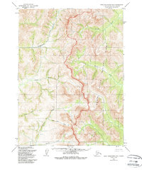
1955 Map of Baird Mountains B-3
USGS Topo · Published 1988About this map
Kobuk Valley National Park encompasses a significant portion of this wilderness landscape, where the eastern slopes of the Kallarichuk Hills meet a network of high-latitude waterways. Surveyed in the mid-1950s, the map documents a terrain defined entirely by its drainage systems, featuring the Nikok River and Kitlik River flowing through the valley. The presence of Gold Run Creek and Klery Creek in the southwest suggests a landscape shaped by historical prospecting interests typical of the region's mineral history. Small tributaries such as Timber Creek and Spruce Creek feed into the larger river systems, illustrating the intricate hydrology of the Northwest Arctic before modern administrative revisions. This topographic study focuses on the natural elevation and watercourses that dictated travel and survival in this remote Alaskan borough.
Find a feature on this map
11 named features on this map. Tap any name to fly to it.
Don’t see what you’re looking for? This feature index may not catch every label — zoom into the map to look around manually.
Map Details
Editions of this 1955 Baird Mountains B-3 Map
2 editions found
Other maps of this area

1951 · Baird Mountains
USGS Topo · 1:250,000

1955 · Baird Mountains A-2
USGS Topo · 1:63,360

1955 · Baird Mountains C-4
USGS Topo · 1:63,360

1955 · Baird Mountains B-3
USGS Topo · 1:63,360

1955 · Baird Mountains A-3
USGS Topo · 1:63,360
1955 · Baird Mountains B-4
USGS Topo · 1:63,360

1955 · Baird Mountains C-3
USGS Topo · 1:63,360

1955 · Baird Mountains A-4
USGS Topo · 1:63,360

1956 · Baird Mountains
USGS Topo · 1:250,000

1965 · Baird Mountains
USGS Topo · 1:250,000