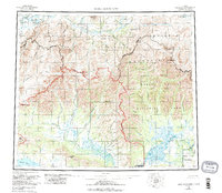
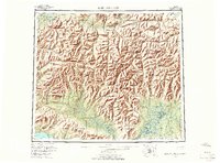
1956 Map of Baird Mountains
USGS Topo · Published 1988About this map
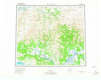
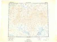
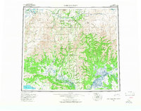
The Baird Mountains and Maiyumerak Mountains dominate this 1950s survey of the Northwest Arctic, where the drainage basins of the Noatak River and Kobuk River meet. The geography is defined by narrow canyons and sprawling river systems, including the Noatak Canyon and the high peaks of the Isachefuich Mountains. Human presence is sparse and temporary, evidenced by scattered Cabins and the Squirrel River Landing Strip, reflecting an era of aviation-dependent access and seasonal subsistence.
Find a feature on this map
67 named features on this map. Tap any name to fly to it.
Don’t see what you’re looking for? This feature index may not catch every label — zoom into the map to look around manually.
Map Details
Editions of this 1956 Baird Mountains Map
7 editions found
Historical Maps of Klery Creek Through Time
847 maps found

1950 Bendeleben C-1
Northwest Arctic Borough, AK

1950 Bendeleben C-2
Northwest Arctic Borough, AK

1950 Bendeleben C-3
Northwest Arctic Borough, AK

1950 Bendeleben C-4
Northwest Arctic Borough, AK

1950 Bendeleben D-1
Northwest Arctic Borough, AK

1950 Bendeleben D-2
Northwest Arctic Borough, AK

1950 Bendeleben D-3
Northwest Arctic Borough, AK

1950 Bendeleben D-4
Northwest Arctic Borough, AK

1950 Candle C-5
Northwest Arctic Borough, AK

1950 Candle C-6
Northwest Arctic Borough, AK

1950 Kotzebue A-1
Northwest Arctic Borough, AK

1950 Kotzebue A-2
Northwest Arctic Borough, AK

1950 Kotzebue A-3
Northwest Arctic Borough, AK

1950 Kotzebue A-4
Northwest Arctic Borough, AK

1950 Kotzebue A-5
Northwest Arctic Borough, AK

1950 Kotzebue B-4
Northwest Arctic Borough, AK

1950 Kotzebue B-5
Northwest Arctic Borough, AK

1950 Kotzebue C-4
Northwest Arctic Borough, AK

1950 Kotzebue C-5
Northwest Arctic Borough, AK

1951 Ambler River
Northwest Arctic Borough, AK

1951 Baird Mountains
Northwest Arctic Borough, AK

1951 Candle D-5
Northwest Arctic Borough, AK

1951 Candle D-6
Northwest Arctic Borough, AK

1951 Candle
Northwest Arctic Borough, AK

1951 Kotzebue C-1
Northwest Arctic Borough, AK

1951 Kotzebue D-1
Northwest Arctic Borough, AK

1951 Kotzebue D-2
Northwest Arctic Borough, AK

1951 Selawik A-5
Northwest Arctic Borough, AK

1951 Selawik A-6
Northwest Arctic Borough, AK

1951 Selawik B-5
Northwest Arctic Borough, AK

1951 Selawik B-6
Northwest Arctic Borough, AK

1951 Selawik C-6
Northwest Arctic Borough, AK

1951 Selawik D-6
Northwest Arctic Borough, AK

1952 Noatak A-3
Northwest Arctic Borough, AK

1952 Noatak A-4
Northwest Arctic Borough, AK

1952 Noatak C-5
Northwest Arctic Borough, AK

1952 Noatak D-7
Northwest Arctic Borough, AK

1952 Selawik D-6
Northwest Arctic Borough, AK

1954 Candle C-2
Northwest Arctic Borough, AK

1954 Candle D-2
Northwest Arctic Borough, AK

1955 Ambler River A-4
Northwest Arctic Borough, AK

1955 Ambler River A-5
Northwest Arctic Borough, AK

1955 Ambler River A-6
Northwest Arctic Borough, AK

1955 Baird Mountains A-1
Northwest Arctic Borough, AK

1955 Baird Mountains A-2
Northwest Arctic Borough, AK

1955 Baird Mountains A-3
Northwest Arctic Borough, AK

1955 Baird Mountains A-4
Northwest Arctic Borough, AK

1955 Baird Mountains A-5
Northwest Arctic Borough, AK

1955 Baird Mountains A-6
Northwest Arctic Borough, AK

1955 Baird Mountains B-3
Northwest Arctic Borough, AK

1955 Baird Mountains B-4
Northwest Arctic Borough, AK

1955 Baird Mountains B-5
Northwest Arctic Borough, AK

1955 Baird Mountains B-6
Northwest Arctic Borough, AK

1955 Baird Mountains C-3
Northwest Arctic Borough, AK

1955 Baird Mountains C-4
Northwest Arctic Borough, AK

1955 Baird Mountains C-5
Northwest Arctic Borough, AK

1955 Baird Mountains C-6
Northwest Arctic Borough, AK

1955 Baird Mountains D-3
Northwest Arctic Borough, AK

1955 Baird Mountains D-4
Northwest Arctic Borough, AK

1955 Baird Mountains D-5
Northwest Arctic Borough, AK

1955 Baird Mountains D-6
Northwest Arctic Borough, AK

1955 Candle C-3
Northwest Arctic Borough, AK

1955 Candle C-4
Northwest Arctic Borough, AK

1955 Candle D-3
Northwest Arctic Borough, AK

1955 Candle D-4
Northwest Arctic Borough, AK

1955 Candle
Northwest Arctic Borough, AK

1955 De Long Mountains A-1
Northwest Arctic Borough, AK

1955 De Long Mountains A-2
Northwest Arctic Borough, AK

1955 De Long Mountains A-3
Northwest Arctic Borough, AK

1955 De Long Mountains A-4
Northwest Arctic Borough, AK

1955 Misheguk Mountain A-3
Northwest Arctic Borough, AK

1955 Misheguk Mountain A-4
Northwest Arctic Borough, AK

1955 Misheguk Mountain A-5
Northwest Arctic Borough, AK

1955 Noatak A-1
Northwest Arctic Borough, AK

1955 Noatak A-2
Northwest Arctic Borough, AK

1955 Noatak B-1
Northwest Arctic Borough, AK

1955 Noatak B-2
Northwest Arctic Borough, AK

1955 Noatak B-3
Northwest Arctic Borough, AK

1955 Noatak B-4
Northwest Arctic Borough, AK

1955 Noatak C-1
Northwest Arctic Borough, AK

1955 Noatak C-2
Northwest Arctic Borough, AK

1955 Noatak C-3
Northwest Arctic Borough, AK

1955 Noatak C-4
Northwest Arctic Borough, AK

1955 Noatak D-1
Northwest Arctic Borough, AK

1955 Noatak D-2
Northwest Arctic Borough, AK

1955 Noatak D-3
Northwest Arctic Borough, AK

1955 Noatak D-4
Northwest Arctic Borough, AK

1955 Noatak D-5
Northwest Arctic Borough, AK

1955 Noatak D-6
Northwest Arctic Borough, AK

1955 Selawik A-3
Northwest Arctic Borough, AK

1955 Selawik A-4
Northwest Arctic Borough, AK

1955 Selawik B-3
Northwest Arctic Borough, AK

1955 Selawik B-4
Northwest Arctic Borough, AK

1955 Selawik C-3
Northwest Arctic Borough, AK

1955 Selawik C-4
Northwest Arctic Borough, AK

1955 Selawik C-5
Northwest Arctic Borough, AK

1955 Selawik D-1
Northwest Arctic Borough, AK

1955 Selawik D-2
Northwest Arctic Borough, AK

1955 Selawik D-3
Northwest Arctic Borough, AK

1955 Selawik D-4
Northwest Arctic Borough, AK

1955 Selawik D-5
Northwest Arctic Borough, AK

1955 Shungnak D-2
Northwest Arctic Borough, AK

1955 Shungnak D-3
Northwest Arctic Borough, AK

1955 Shungnak D-4
Northwest Arctic Borough, AK

1955 Shungnak D-5
Northwest Arctic Borough, AK

1955 Shungnak D-6
Northwest Arctic Borough, AK

1956 Ambler River
Northwest Arctic Borough, AK

1956 Baird Mountains
Northwest Arctic Borough, AK

1964 Ambler River
Northwest Arctic Borough, AK

1964 Candle
Northwest Arctic Borough, AK

1965 Baird Mountains
Northwest Arctic Borough, AK

1966 Ambler River A-4
Northwest Arctic Borough, AK

1984 Howard Pass A-2
Northwest Arctic Borough, AK

1984 Howard Pass A-3
Northwest Arctic Borough, AK

1984 Survey Pass D-6
Northwest Arctic Borough, AK

1985 Ambler River A-1
Northwest Arctic Borough, AK

1985 Ambler River A-2
Northwest Arctic Borough, AK

1985 Ambler River A-3
Northwest Arctic Borough, AK

1985 Selawik A-1
Northwest Arctic Borough, AK

1985 Selawik A-2
Northwest Arctic Borough, AK

1985 Selawik B-1
Northwest Arctic Borough, AK

1985 Selawik B-2
Northwest Arctic Borough, AK

1985 Selawik C-1
Northwest Arctic Borough, AK

1985 Selawik C-2
Northwest Arctic Borough, AK

1985 Shungnak A-6
Northwest Arctic Borough, AK

1985 Shungnak B-2
Northwest Arctic Borough, AK

1985 Shungnak B-5
Northwest Arctic Borough, AK

1985 Shungnak B-6
Northwest Arctic Borough, AK

1985 Shungnak C-1
Northwest Arctic Borough, AK

1985 Shungnak C-2
Northwest Arctic Borough, AK

1985 Shungnak C-3
Northwest Arctic Borough, AK

1985 Shungnak C-4
Northwest Arctic Borough, AK

1985 Shungnak C-5
Northwest Arctic Borough, AK

1985 Shungnak C-6
Northwest Arctic Borough, AK

1985 Shungnak D-1
Northwest Arctic Borough, AK

1986 Hughes B-6
Northwest Arctic Borough, AK

1986 Hughes C-5
Northwest Arctic Borough, AK

1986 Hughes C-6
Northwest Arctic Borough, AK

1986 Hughes D-3
Northwest Arctic Borough, AK

1986 Hughes D-4
Northwest Arctic Borough, AK

1986 Hughes D-5
Northwest Arctic Borough, AK

1986 Hughes D-6
Northwest Arctic Borough, AK

1986 Survey Pass A-3
Northwest Arctic Borough, AK

1986 Survey Pass A-4
Northwest Arctic Borough, AK

1986 Survey Pass A-5
Northwest Arctic Borough, AK

1986 Survey Pass A-6
Northwest Arctic Borough, AK

1990 Ambler River B-1
Northwest Arctic Borough, AK

1990 Ambler River B-2
Northwest Arctic Borough, AK

1990 Ambler River B-3
Northwest Arctic Borough, AK

1990 Ambler River B-4
Northwest Arctic Borough, AK

1990 Ambler River B-5
Northwest Arctic Borough, AK

1990 Ambler River B-6
Northwest Arctic Borough, AK

1990 Ambler River C-1
Northwest Arctic Borough, AK

1990 Ambler River C-2
Northwest Arctic Borough, AK

1990 Ambler River C-3
Northwest Arctic Borough, AK

1990 Ambler River C-4
Northwest Arctic Borough, AK

1990 Ambler River C-5
Northwest Arctic Borough, AK

1990 Ambler River C-6
Northwest Arctic Borough, AK

1990 Ambler River D-1
Northwest Arctic Borough, AK

1990 Ambler River D-2
Northwest Arctic Borough, AK

1990 Ambler River D-3
Northwest Arctic Borough, AK

1990 Ambler River D-4
Northwest Arctic Borough, AK

1990 Ambler River D-5
Northwest Arctic Borough, AK

1990 Ambler River D-6
Northwest Arctic Borough, AK

1990 Baird Mountains B-1
Northwest Arctic Borough, AK

1990 Baird Mountains B-2
Northwest Arctic Borough, AK

1990 Baird Mountains C-1
Northwest Arctic Borough, AK

1990 Baird Mountains C-2
Northwest Arctic Borough, AK

1990 Baird Mountains D-1
Northwest Arctic Borough, AK

1990 Baird Mountains D-2
Northwest Arctic Borough, AK

1990 Howard Pass A-4
Northwest Arctic Borough, AK

1990 Howard Pass A-5
Northwest Arctic Borough, AK

1990 Misheguk Mountain A-1
Northwest Arctic Borough, AK

1990 Misheguk Mountain A-2
Northwest Arctic Borough, AK

1990 Survey Pass B-4
Northwest Arctic Borough, AK

1990 Survey Pass B-5
Northwest Arctic Borough, AK

1990 Survey Pass B-6
Northwest Arctic Borough, AK

1990 Survey Pass C-5
Northwest Arctic Borough, AK

1990 Survey Pass C-6
Northwest Arctic Borough, AK

2014 Baird Mountains A-5 NE
Northwest Arctic Borough, AK

2014 Baird Mountains A-5 NW
Northwest Arctic Borough, AK

2014 Baird Mountains A-5 SE
Northwest Arctic Borough, AK

2014 Baird Mountains A-5 SW
Northwest Arctic Borough, AK

2014 Baird Mountains A-6 NE
Northwest Arctic Borough, AK

2014 Baird Mountains A-6 SE
Northwest Arctic Borough, AK

2014 Baird Mountains B-5 NE
Northwest Arctic Borough, AK

2014 Baird Mountains B-5 SE
Northwest Arctic Borough, AK

2014 Baird Mountains B-5 SW
Northwest Arctic Borough, AK

2014 Baird Mountains B-6 SE
Northwest Arctic Borough, AK

2014 Baird Mountains C-4 NW
Northwest Arctic Borough, AK

2014 Baird Mountains C-4 SW
Northwest Arctic Borough, AK

2014 Baird Mountains C-5 NE
Northwest Arctic Borough, AK

2014 Baird Mountains C-5 SE
Northwest Arctic Borough, AK

2014 Baird Mountains D-4 NW
Northwest Arctic Borough, AK

2014 Baird Mountains D-4 SW
Northwest Arctic Borough, AK

2014 Bendeleben C-1 NE
Northwest Arctic Borough, AK

2014 Bendeleben D-1 SE
Northwest Arctic Borough, AK

2014 Bendeleben D-4 NW
Northwest Arctic Borough, AK

2014 Bendeleben D-5 NE
Northwest Arctic Borough, AK

2014 Candle B-3 NE
Northwest Arctic Borough, AK

2014 Candle C-2 NW
Northwest Arctic Borough, AK

2014 Candle C-2 SW
Northwest Arctic Borough, AK

2014 Candle C-3 NE
Northwest Arctic Borough, AK

2014 Candle C-3 NW
Northwest Arctic Borough, AK

2014 Candle C-3 SE
Northwest Arctic Borough, AK

2014 Candle C-3 SW
Northwest Arctic Borough, AK

2014 Candle C-4 NE
Northwest Arctic Borough, AK

2014 Candle C-4 NW
Northwest Arctic Borough, AK

2014 Candle C-4 SE
Northwest Arctic Borough, AK

2014 Candle C-4 SW
Northwest Arctic Borough, AK

2014 Candle C-5 NE
Northwest Arctic Borough, AK

2014 Candle C-5 NW
Northwest Arctic Borough, AK

2014 Candle C-5 SE
Northwest Arctic Borough, AK

2014 Candle C-5 SW
Northwest Arctic Borough, AK

2014 Candle C-6 NE
Northwest Arctic Borough, AK

2014 Candle C-6 NW
Northwest Arctic Borough, AK

2014 Candle C-6 SE
Northwest Arctic Borough, AK

2014 Candle D-2 NE
Northwest Arctic Borough, AK

2014 Candle D-2 NW
Northwest Arctic Borough, AK

2014 Candle D-2 SE
Northwest Arctic Borough, AK

2014 Candle D-2 SW
Northwest Arctic Borough, AK

2014 Candle D-3 NE
Northwest Arctic Borough, AK

2014 Candle D-3 NW
Northwest Arctic Borough, AK

2014 Candle D-3 SE
Northwest Arctic Borough, AK

2014 Candle D-3 SW
Northwest Arctic Borough, AK

2014 Candle D-4 NE
Northwest Arctic Borough, AK

2014 Candle D-4 NW
Northwest Arctic Borough, AK

2014 Candle D-4 SE
Northwest Arctic Borough, AK

2014 Candle D-4 SW
Northwest Arctic Borough, AK

2014 Candle D-5 NE
Northwest Arctic Borough, AK

2014 Candle D-5 NW
Northwest Arctic Borough, AK

2014 Candle D-5 SE
Northwest Arctic Borough, AK

2014 Candle D-5 SW
Northwest Arctic Borough, AK

2014 Candle D-6 NE
Northwest Arctic Borough, AK

2014 Candle D-6 SE
Northwest Arctic Borough, AK

2014 Candle D-6 SW
Northwest Arctic Borough, AK

2014 De Long Mountains A-4 SW
Northwest Arctic Borough, AK

2014 Kotzebue A-4 NW
Northwest Arctic Borough, AK

2014 Kotzebue A-4 SW
Northwest Arctic Borough, AK

2014 Kotzebue A-5 NE
Northwest Arctic Borough, AK

2014 Kotzebue A-5 SE
Northwest Arctic Borough, AK

2014 Kotzebue B-4 NE
Northwest Arctic Borough, AK

2014 Kotzebue B-4 NW
Northwest Arctic Borough, AK

2014 Kotzebue B-4 SE
Northwest Arctic Borough, AK

2014 Kotzebue B-4 SW
Northwest Arctic Borough, AK

2014 Kotzebue B-5 NE
Northwest Arctic Borough, AK

2014 Kotzebue B-5 SE
Northwest Arctic Borough, AK

2014 Kotzebue C-1 NW
Northwest Arctic Borough, AK

2014 Kotzebue C-1 OE W NE
Northwest Arctic Borough, AK

2014 Kotzebue C-4 SE
Northwest Arctic Borough, AK

2014 Kotzebue C-4 SW
Northwest Arctic Borough, AK

2014 Kotzebue C-5 SE
Northwest Arctic Borough, AK

2014 Kotzebue C-5 SW
Northwest Arctic Borough, AK

2014 Noatak A-4 NW
Northwest Arctic Borough, AK

2014 Noatak B-4 NE
Northwest Arctic Borough, AK

2014 Noatak B-4 SE
Northwest Arctic Borough, AK

2014 Noatak B-4 SW
Northwest Arctic Borough, AK

2014 Noatak C-3 NE
Northwest Arctic Borough, AK

2014 Noatak C-3 NW
Northwest Arctic Borough, AK

2014 Noatak C-4 NE
Northwest Arctic Borough, AK

2014 Noatak C-4 SE
Northwest Arctic Borough, AK

2014 Noatak C-5 OE W NE
Northwest Arctic Borough, AK

2014 Noatak D-3 NW
Northwest Arctic Borough, AK

2014 Noatak D-3 SE
Northwest Arctic Borough, AK

2014 Noatak D-3 SW
Northwest Arctic Borough, AK

2014 Noatak D-4 NE
Northwest Arctic Borough, AK

2014 Noatak D-4 NW
Northwest Arctic Borough, AK

2014 Noatak D-4 SE
Northwest Arctic Borough, AK

2014 Noatak D-4 SW
Northwest Arctic Borough, AK

2014 Noatak D-5 NE
Northwest Arctic Borough, AK

2014 Noatak D-5 NW
Northwest Arctic Borough, AK

2014 Noatak D-5 SE
Northwest Arctic Borough, AK

2014 Noatak D-5 SW
Northwest Arctic Borough, AK

2014 Noatak D-6 NE
Northwest Arctic Borough, AK

2014 Noatak D-6 NW
Northwest Arctic Borough, AK

2014 Noatak D-6 SE
Northwest Arctic Borough, AK

2014 Noatak D-6 SW
Northwest Arctic Borough, AK

2014 Noatak D-7 NE
Northwest Arctic Borough, AK

2014 Selawik A-1 NE
Northwest Arctic Borough, AK

2014 Selawik A-2 NW
Northwest Arctic Borough, AK

2014 Selawik A-2 SE
Northwest Arctic Borough, AK

2014 Selawik A-2 SW
Northwest Arctic Borough, AK

2014 Selawik A-3 NW
Northwest Arctic Borough, AK

2014 Selawik A-3 SE
Northwest Arctic Borough, AK

2014 Selawik A-3 SW
Northwest Arctic Borough, AK

2014 Selawik A-4 NE
Northwest Arctic Borough, AK

2014 Selawik A-4 NW
Northwest Arctic Borough, AK

2014 Selawik A-4 SE
Northwest Arctic Borough, AK

2014 Selawik A-4 SW
Northwest Arctic Borough, AK

2014 Selawik A-5 NE
Northwest Arctic Borough, AK

2014 Selawik A-5 NW
Northwest Arctic Borough, AK

2014 Selawik A-5 SE
Northwest Arctic Borough, AK

2014 Selawik A-5 SW
Northwest Arctic Borough, AK

2014 Selawik A-6 NE
Northwest Arctic Borough, AK

2014 Selawik A-6 NW
Northwest Arctic Borough, AK

2014 Selawik A-6 SE
Northwest Arctic Borough, AK

2014 Selawik B-3 SW
Northwest Arctic Borough, AK

2014 Selawik B-4 SE
Northwest Arctic Borough, AK

2014 Selawik B-6 SE
Northwest Arctic Borough, AK

2014 Selawik D-6 NW
Northwest Arctic Borough, AK

2014 Selawik D-6 SW
Northwest Arctic Borough, AK

2015 Ambler River A-3 NW
Northwest Arctic Borough, AK

2015 Ambler River A-4 NE
Northwest Arctic Borough, AK

2015 Ambler River A-4 NW
Northwest Arctic Borough, AK

2015 Ambler River A-4 SW
Northwest Arctic Borough, AK

2015 Ambler River A-5 NE
Northwest Arctic Borough, AK

2015 Ambler River A-5 NW
Northwest Arctic Borough, AK

2015 Ambler River A-5 SE
Northwest Arctic Borough, AK

2015 Ambler River A-5 SW
Northwest Arctic Borough, AK

2015 Ambler River A-6 NE
Northwest Arctic Borough, AK

2015 Ambler River A-6 NW
Northwest Arctic Borough, AK

2015 Ambler River A-6 SE
Northwest Arctic Borough, AK

2015 Ambler River A-6 SW
Northwest Arctic Borough, AK

2015 Ambler River B-3 SW
Northwest Arctic Borough, AK

2015 Ambler River B-4 NE
Northwest Arctic Borough, AK

2015 Ambler River B-4 NW
Northwest Arctic Borough, AK

2015 Ambler River B-4 SE
Northwest Arctic Borough, AK

2015 Ambler River B-4 SW
Northwest Arctic Borough, AK

2015 Ambler River B-5 NE
Northwest Arctic Borough, AK

2015 Ambler River B-5 NW
Northwest Arctic Borough, AK

2015 Ambler River B-5 SE
Northwest Arctic Borough, AK

2015 Ambler River B-5 SW
Northwest Arctic Borough, AK

2015 Ambler River B-6 NE
Northwest Arctic Borough, AK

2015 Ambler River B-6 NW
Northwest Arctic Borough, AK

2015 Ambler River B-6 SE
Northwest Arctic Borough, AK

2015 Ambler River B-6 SW
Northwest Arctic Borough, AK

2015 Ambler River C-4 SW
Northwest Arctic Borough, AK

2015 Ambler River C-5 NE
Northwest Arctic Borough, AK

2015 Ambler River C-5 NW
Northwest Arctic Borough, AK

2015 Ambler River C-5 SE
Northwest Arctic Borough, AK

2015 Ambler River C-5 SW
Northwest Arctic Borough, AK

2015 Ambler River C-6 NE
Northwest Arctic Borough, AK

2015 Ambler River C-6 NW
Northwest Arctic Borough, AK

2015 Ambler River C-6 SE
Northwest Arctic Borough, AK

2015 Ambler River C-6 SW
Northwest Arctic Borough, AK

2015 Ambler River D-5 NE
Northwest Arctic Borough, AK

2015 Ambler River D-5 NW
Northwest Arctic Borough, AK

2015 Ambler River D-5 SE
Northwest Arctic Borough, AK

2015 Ambler River D-5 SW
Northwest Arctic Borough, AK

2015 Ambler River D-6 NE
Northwest Arctic Borough, AK

2015 Ambler River D-6 NW
Northwest Arctic Borough, AK

2015 Ambler River D-6 SE
Northwest Arctic Borough, AK

2015 Ambler River D-6 SW
Northwest Arctic Borough, AK

2015 Baird Mountains A-1 NE
Northwest Arctic Borough, AK

2015 Baird Mountains A-1 NW
Northwest Arctic Borough, AK

2015 Baird Mountains A-1 SE
Northwest Arctic Borough, AK

2015 Baird Mountains A-1 SW
Northwest Arctic Borough, AK

2015 Baird Mountains A-2 NE
Northwest Arctic Borough, AK

2015 Baird Mountains A-2 NW
Northwest Arctic Borough, AK

2015 Baird Mountains A-2 SE
Northwest Arctic Borough, AK

2015 Baird Mountains A-2 SW
Northwest Arctic Borough, AK

2015 Baird Mountains A-3 NE
Northwest Arctic Borough, AK

2015 Baird Mountains A-3 NW
Northwest Arctic Borough, AK

2015 Baird Mountains A-3 SE
Northwest Arctic Borough, AK

2015 Baird Mountains A-3 SW
Northwest Arctic Borough, AK

2015 Baird Mountains A-4 NE
Northwest Arctic Borough, AK

2015 Baird Mountains A-4 NW
Northwest Arctic Borough, AK

2015 Baird Mountains A-4 SE
Northwest Arctic Borough, AK

2015 Baird Mountains A-4 SW
Northwest Arctic Borough, AK

2015 Baird Mountains A-6 NW
Northwest Arctic Borough, AK

2015 Baird Mountains B-1 NE
Northwest Arctic Borough, AK

2015 Baird Mountains B-1 NW
Northwest Arctic Borough, AK

2015 Baird Mountains B-1 SE
Northwest Arctic Borough, AK

2015 Baird Mountains B-1 SW
Northwest Arctic Borough, AK

2015 Baird Mountains B-2 NE
Northwest Arctic Borough, AK

2015 Baird Mountains B-2 NW
Northwest Arctic Borough, AK

2015 Baird Mountains B-2 SE
Northwest Arctic Borough, AK

2015 Baird Mountains B-2 SW
Northwest Arctic Borough, AK

2015 Baird Mountains B-3 NE
Northwest Arctic Borough, AK

2015 Baird Mountains B-3 NW
Northwest Arctic Borough, AK

2015 Baird Mountains B-3 SE
Northwest Arctic Borough, AK

2015 Baird Mountains B-3 SW
Northwest Arctic Borough, AK

2015 Baird Mountains B-4 NE
Northwest Arctic Borough, AK

2015 Baird Mountains B-4 NW
Northwest Arctic Borough, AK

2015 Baird Mountains B-4 SE
Northwest Arctic Borough, AK

2015 Baird Mountains B-4 SW
Northwest Arctic Borough, AK

2015 Baird Mountains B-5 NW
Northwest Arctic Borough, AK

2015 Baird Mountains B-6 NE
Northwest Arctic Borough, AK

2015 Baird Mountains B-6 NW
Northwest Arctic Borough, AK

2015 Baird Mountains B-6 SW
Northwest Arctic Borough, AK

2015 Baird Mountains C-1 NE
Northwest Arctic Borough, AK

2015 Baird Mountains C-1 NW
Northwest Arctic Borough, AK

2015 Baird Mountains C-1 SE
Northwest Arctic Borough, AK

2015 Baird Mountains C-1 SW
Northwest Arctic Borough, AK

2015 Baird Mountains C-2 NE
Northwest Arctic Borough, AK

2015 Baird Mountains C-2 NW
Northwest Arctic Borough, AK

2015 Baird Mountains C-2 SE
Northwest Arctic Borough, AK

2015 Baird Mountains C-2 SW
Northwest Arctic Borough, AK

2015 Baird Mountains C-3 NE
Northwest Arctic Borough, AK

2015 Baird Mountains C-3 NW
Northwest Arctic Borough, AK

2015 Baird Mountains C-3 SE
Northwest Arctic Borough, AK

2015 Baird Mountains C-3 SW
Northwest Arctic Borough, AK

2015 Baird Mountains C-4 NE
Northwest Arctic Borough, AK

2015 Baird Mountains C-4 SE
Northwest Arctic Borough, AK

2015 Baird Mountains C-5 NW
Northwest Arctic Borough, AK

2015 Baird Mountains C-5 SW
Northwest Arctic Borough, AK

2015 Baird Mountains C-6 NE
Northwest Arctic Borough, AK

2015 Baird Mountains C-6 NW
Northwest Arctic Borough, AK

2015 Baird Mountains C-6 SE
Northwest Arctic Borough, AK

2015 Baird Mountains C-6 SW
Northwest Arctic Borough, AK

2015 Baird Mountains D-1 NE
Northwest Arctic Borough, AK

2015 Baird Mountains D-1 NW
Northwest Arctic Borough, AK

2015 Baird Mountains D-1 SE
Northwest Arctic Borough, AK

2015 Baird Mountains D-1 SW
Northwest Arctic Borough, AK

2015 Baird Mountains D-2 NE
Northwest Arctic Borough, AK

2015 Baird Mountains D-2 NW
Northwest Arctic Borough, AK

2015 Baird Mountains D-2 SE
Northwest Arctic Borough, AK

2015 Baird Mountains D-2 SW
Northwest Arctic Borough, AK

2015 Baird Mountains D-3 NE
Northwest Arctic Borough, AK

2015 Baird Mountains D-3 NW
Northwest Arctic Borough, AK

2015 Baird Mountains D-3 SE
Northwest Arctic Borough, AK

2015 Baird Mountains D-3 SW
Northwest Arctic Borough, AK

2015 Baird Mountains D-4 NE
Northwest Arctic Borough, AK

2015 Baird Mountains D-4 SE
Northwest Arctic Borough, AK

2015 Baird Mountains D-5 NE
Northwest Arctic Borough, AK

2015 Baird Mountains D-5 NW
Northwest Arctic Borough, AK

2015 Baird Mountains D-5 SE
Northwest Arctic Borough, AK

2015 Baird Mountains D-5 SW
Northwest Arctic Borough, AK

2015 Baird Mountains D-6 NE
Northwest Arctic Borough, AK

2015 Baird Mountains D-6 NW
Northwest Arctic Borough, AK

2015 Baird Mountains D-6 SE
Northwest Arctic Borough, AK

2015 Baird Mountains D-6 SW
Northwest Arctic Borough, AK

2015 Candle C-2 NE
Northwest Arctic Borough, AK

2015 Candle C-2 SE
Northwest Arctic Borough, AK

2015 De Long Mountains A-1 NE
Northwest Arctic Borough, AK

2015 De Long Mountains A-1 NW
Northwest Arctic Borough, AK

2015 De Long Mountains A-1 SE
Northwest Arctic Borough, AK

2015 De Long Mountains A-1 SW
Northwest Arctic Borough, AK

2015 De Long Mountains A-2 NE
Northwest Arctic Borough, AK

2015 De Long Mountains A-2 NW
Northwest Arctic Borough, AK

2015 De Long Mountains A-2 SE
Northwest Arctic Borough, AK

2015 De Long Mountains A-2 SW
Northwest Arctic Borough, AK

2015 De Long Mountains A-3 NE
Northwest Arctic Borough, AK

2015 De Long Mountains A-3 NW
Northwest Arctic Borough, AK

2015 De Long Mountains A-3 SE
Northwest Arctic Borough, AK

2015 De Long Mountains A-3 SW
Northwest Arctic Borough, AK

2015 De Long Mountains A-4 NE
Northwest Arctic Borough, AK

2015 De Long Mountains A-4 NW
Northwest Arctic Borough, AK

2015 De Long Mountains A-4 SE
Northwest Arctic Borough, AK

2015 Howard Pass A-4 NW
Northwest Arctic Borough, AK

2015 Howard Pass A-4 SW
Northwest Arctic Borough, AK

2015 Howard Pass A-5 NE
Northwest Arctic Borough, AK

2015 Howard Pass A-5 NW
Northwest Arctic Borough, AK

2015 Howard Pass A-5 SE
Northwest Arctic Borough, AK

2015 Howard Pass A-5 SW
Northwest Arctic Borough, AK

2015 Misheguk Mountain A-1 NE
Northwest Arctic Borough, AK

2015 Misheguk Mountain A-1 NW
Northwest Arctic Borough, AK

2015 Misheguk Mountain A-1 SE
Northwest Arctic Borough, AK

2015 Misheguk Mountain A-1 SW
Northwest Arctic Borough, AK

2015 Misheguk Mountain A-2 NE
Northwest Arctic Borough, AK

2015 Misheguk Mountain A-2 NW
Northwest Arctic Borough, AK

2015 Misheguk Mountain A-2 SE
Northwest Arctic Borough, AK

2015 Misheguk Mountain A-2 SW
Northwest Arctic Borough, AK

2015 Misheguk Mountain A-3 NE
Northwest Arctic Borough, AK

2015 Misheguk Mountain A-3 NW
Northwest Arctic Borough, AK

2015 Misheguk Mountain A-3 SE
Northwest Arctic Borough, AK

2015 Misheguk Mountain A-3 SW
Northwest Arctic Borough, AK

2015 Misheguk Mountain A-4 NE
Northwest Arctic Borough, AK

2015 Misheguk Mountain A-4 NW
Northwest Arctic Borough, AK

2015 Misheguk Mountain A-4 SE
Northwest Arctic Borough, AK

2015 Misheguk Mountain A-4 SW
Northwest Arctic Borough, AK

2015 Misheguk Mountain A-5 NE
Northwest Arctic Borough, AK

2015 Misheguk Mountain A-5 NW
Northwest Arctic Borough, AK

2015 Misheguk Mountain A-5 SE
Northwest Arctic Borough, AK

2015 Misheguk Mountain A-5 SW
Northwest Arctic Borough, AK

2015 Noatak A-1 NE
Northwest Arctic Borough, AK

2015 Noatak A-1 NW
Northwest Arctic Borough, AK

2015 Noatak A-2 NE
Northwest Arctic Borough, AK

2015 Noatak A-2 NW
Northwest Arctic Borough, AK

2015 Noatak A-3 NE
Northwest Arctic Borough, AK

2015 Noatak A-3 NW
Northwest Arctic Borough, AK

2015 Noatak B-1 NE
Northwest Arctic Borough, AK

2015 Noatak B-1 NW
Northwest Arctic Borough, AK

2015 Noatak B-1 SE
Northwest Arctic Borough, AK

2015 Noatak B-1 SW
Northwest Arctic Borough, AK

2015 Noatak B-2 NE
Northwest Arctic Borough, AK

2015 Noatak B-2 NW
Northwest Arctic Borough, AK

2015 Noatak B-2 SE
Northwest Arctic Borough, AK

2015 Noatak B-2 SW
Northwest Arctic Borough, AK

2015 Noatak B-3 NE
Northwest Arctic Borough, AK

2015 Noatak B-3 NW
Northwest Arctic Borough, AK

2015 Noatak B-3 SE
Northwest Arctic Borough, AK

2015 Noatak B-3 SW
Northwest Arctic Borough, AK

2015 Noatak C-1 NE
Northwest Arctic Borough, AK

2015 Noatak C-1 NW
Northwest Arctic Borough, AK

2015 Noatak C-1 SE
Northwest Arctic Borough, AK

2015 Noatak C-1 SW
Northwest Arctic Borough, AK

2015 Noatak C-2 NE
Northwest Arctic Borough, AK

2015 Noatak C-2 NW
Northwest Arctic Borough, AK

2015 Noatak C-2 SE
Northwest Arctic Borough, AK

2015 Noatak C-2 SW
Northwest Arctic Borough, AK

2015 Noatak C-3 SE
Northwest Arctic Borough, AK

2015 Noatak C-3 SW
Northwest Arctic Borough, AK

2015 Noatak C-4 NW
Northwest Arctic Borough, AK

2015 Noatak D-1 NE
Northwest Arctic Borough, AK

2015 Noatak D-1 NW
Northwest Arctic Borough, AK

2015 Noatak D-1 SE
Northwest Arctic Borough, AK

2015 Noatak D-1 SW
Northwest Arctic Borough, AK

2015 Noatak D-2 NE
Northwest Arctic Borough, AK

2015 Noatak D-2 NW
Northwest Arctic Borough, AK

2015 Noatak D-2 SE
Northwest Arctic Borough, AK

2015 Noatak D-2 SW
Northwest Arctic Borough, AK

2015 Noatak D-3 NE
Northwest Arctic Borough, AK

2015 Selawik A-1 NW
Northwest Arctic Borough, AK

2015 Selawik A-1 SE
Northwest Arctic Borough, AK

2015 Selawik A-1 SW
Northwest Arctic Borough, AK

2015 Selawik A-2 NE
Northwest Arctic Borough, AK

2015 Selawik A-3 NE
Northwest Arctic Borough, AK

2015 Selawik B-1 NE
Northwest Arctic Borough, AK

2015 Selawik B-1 NW
Northwest Arctic Borough, AK

2015 Selawik B-1 SE
Northwest Arctic Borough, AK

2015 Selawik B-1 SW
Northwest Arctic Borough, AK

2015 Selawik B-2 SE
Northwest Arctic Borough, AK

2015 Selawik B-2 SW
Northwest Arctic Borough, AK

2015 Selawik B-3 SE
Northwest Arctic Borough, AK

2015 Selawik C-1 NE
Northwest Arctic Borough, AK

2015 Selawik C-1 NW
Northwest Arctic Borough, AK

2015 Selawik C-1 SE
Northwest Arctic Borough, AK

2015 Selawik C-1 SW
Northwest Arctic Borough, AK

2015 Selawik C-2 NE
Northwest Arctic Borough, AK

2015 Selawik C-2 NW
Northwest Arctic Borough, AK

2015 Selawik C-5 NW
Northwest Arctic Borough, AK

2015 Selawik D-1 NE
Northwest Arctic Borough, AK

2015 Selawik D-1 NW
Northwest Arctic Borough, AK

2015 Selawik D-1 SE
Northwest Arctic Borough, AK

2015 Selawik D-1 SW
Northwest Arctic Borough, AK

2015 Selawik D-2 NE
Northwest Arctic Borough, AK

2015 Selawik D-2 NW
Northwest Arctic Borough, AK

2015 Selawik D-2 SE
Northwest Arctic Borough, AK

2015 Selawik D-2 SW
Northwest Arctic Borough, AK

2015 Selawik D-3 NE
Northwest Arctic Borough, AK

2015 Selawik D-3 NW
Northwest Arctic Borough, AK

2015 Selawik D-3 SE
Northwest Arctic Borough, AK

2015 Selawik D-3 SW
Northwest Arctic Borough, AK

2015 Selawik D-4 NE
Northwest Arctic Borough, AK

2015 Selawik D-4 NW
Northwest Arctic Borough, AK

2015 Selawik D-4 SE
Northwest Arctic Borough, AK

2015 Selawik D-4 SW
Northwest Arctic Borough, AK

2015 Selawik D-5 NE
Northwest Arctic Borough, AK

2015 Selawik D-5 SE
Northwest Arctic Borough, AK

2015 Selawik D-5 SW
Northwest Arctic Borough, AK

2015 Selawik D-6 SE
Northwest Arctic Borough, AK

2015 Shungnak A-6 NE
Northwest Arctic Borough, AK

2015 Shungnak A-6 NW
Northwest Arctic Borough, AK

2015 Shungnak B-5 NW
Northwest Arctic Borough, AK

2015 Shungnak B-6 NE
Northwest Arctic Borough, AK

2015 Shungnak B-6 NW
Northwest Arctic Borough, AK

2015 Shungnak B-6 SE
Northwest Arctic Borough, AK

2015 Shungnak B-6 SW
Northwest Arctic Borough, AK

2015 Shungnak C-5 NW
Northwest Arctic Borough, AK

2015 Shungnak C-5 SW
Northwest Arctic Borough, AK

2015 Shungnak C-6 NE
Northwest Arctic Borough, AK

2015 Shungnak C-6 NW
Northwest Arctic Borough, AK

2015 Shungnak C-6 SE
Northwest Arctic Borough, AK

2015 Shungnak C-6 SW
Northwest Arctic Borough, AK

2015 Shungnak D-4 NW
Northwest Arctic Borough, AK

2015 Shungnak D-4 SW
Northwest Arctic Borough, AK

2015 Shungnak D-5 NE
Northwest Arctic Borough, AK

2015 Shungnak D-5 NW
Northwest Arctic Borough, AK

2015 Shungnak D-5 SE
Northwest Arctic Borough, AK

2015 Shungnak D-5 SW
Northwest Arctic Borough, AK

2015 Shungnak D-6 NE
Northwest Arctic Borough, AK

2015 Shungnak D-6 NW
Northwest Arctic Borough, AK

2015 Shungnak D-6 SE
Northwest Arctic Borough, AK

2015 Shungnak D-6 SW
Northwest Arctic Borough, AK

2016 Ambler River A-1 NE
Northwest Arctic Borough, AK

2016 Ambler River A-1 NW
Northwest Arctic Borough, AK

2016 Ambler River A-1 SE
Northwest Arctic Borough, AK

2016 Ambler River A-1 SW
Northwest Arctic Borough, AK

2016 Ambler River A-2 NE
Northwest Arctic Borough, AK

2016 Ambler River A-2 NW
Northwest Arctic Borough, AK

2016 Ambler River A-2 SE
Northwest Arctic Borough, AK

2016 Ambler River A-2 SW
Northwest Arctic Borough, AK

2016 Ambler River A-3 NE
Northwest Arctic Borough, AK

2016 Ambler River A-3 SE
Northwest Arctic Borough, AK

2016 Ambler River A-3 SW
Northwest Arctic Borough, AK

2016 Ambler River A-4 SE
Northwest Arctic Borough, AK

2016 Ambler River B-1 NE
Northwest Arctic Borough, AK

2016 Ambler River B-1 NW
Northwest Arctic Borough, AK

2016 Ambler River B-1 SE
Northwest Arctic Borough, AK

2016 Ambler River B-1 SW
Northwest Arctic Borough, AK

2016 Ambler River B-2 NE
Northwest Arctic Borough, AK

2016 Ambler River B-2 NW
Northwest Arctic Borough, AK

2016 Ambler River B-2 SE
Northwest Arctic Borough, AK

2016 Ambler River B-2 SW
Northwest Arctic Borough, AK

2016 Ambler River B-3 NE
Northwest Arctic Borough, AK

2016 Ambler River B-3 NW
Northwest Arctic Borough, AK

2016 Ambler River B-3 SE
Northwest Arctic Borough, AK

2016 Ambler River C-1 NE
Northwest Arctic Borough, AK

2016 Ambler River C-1 NW
Northwest Arctic Borough, AK

2016 Ambler River C-1 SE
Northwest Arctic Borough, AK

2016 Ambler River C-1 SW
Northwest Arctic Borough, AK

2016 Ambler River C-2 NE
Northwest Arctic Borough, AK

2016 Ambler River C-2 NW
Northwest Arctic Borough, AK

2016 Ambler River C-2 SE
Northwest Arctic Borough, AK

2016 Ambler River C-2 SW
Northwest Arctic Borough, AK

2016 Ambler River C-3 NE
Northwest Arctic Borough, AK

2016 Ambler River C-3 NW
Northwest Arctic Borough, AK

2016 Ambler River C-3 SE
Northwest Arctic Borough, AK

2016 Ambler River C-3 SW
Northwest Arctic Borough, AK

2016 Ambler River C-4 NE
Northwest Arctic Borough, AK

2016 Ambler River C-4 NW
Northwest Arctic Borough, AK

2016 Ambler River C-4 SE
Northwest Arctic Borough, AK

2016 Ambler River D-1 NE
Northwest Arctic Borough, AK

2016 Ambler River D-1 NW
Northwest Arctic Borough, AK

2016 Ambler River D-1 SE
Northwest Arctic Borough, AK

2016 Ambler River D-1 SW
Northwest Arctic Borough, AK

2016 Ambler River D-2 NE
Northwest Arctic Borough, AK

2016 Ambler River D-2 NW
Northwest Arctic Borough, AK

2016 Ambler River D-2 SE
Northwest Arctic Borough, AK

2016 Ambler River D-2 SW
Northwest Arctic Borough, AK

2016 Ambler River D-3 NE
Northwest Arctic Borough, AK

2016 Ambler River D-3 NW
Northwest Arctic Borough, AK

2016 Ambler River D-3 SE
Northwest Arctic Borough, AK

2016 Ambler River D-3 SW
Northwest Arctic Borough, AK

2016 Ambler River D-4 NE
Northwest Arctic Borough, AK

2016 Ambler River D-4 NW
Northwest Arctic Borough, AK

2016 Ambler River D-4 SE
Northwest Arctic Borough, AK

2016 Ambler River D-4 SW
Northwest Arctic Borough, AK

2016 Baird Mountains A-6 SW
Northwest Arctic Borough, AK

2016 Howard Pass A-1 SW
Northwest Arctic Borough, AK

2016 Howard Pass A-2 SE
Northwest Arctic Borough, AK

2016 Hughes B-6 NE
Northwest Arctic Borough, AK

2016 Hughes B-6 NW
Northwest Arctic Borough, AK

2016 Hughes C-4 NW
Northwest Arctic Borough, AK

2016 Hughes C-5 NE
Northwest Arctic Borough, AK

2016 Hughes C-5 NW
Northwest Arctic Borough, AK

2016 Hughes C-6 NE
Northwest Arctic Borough, AK

2016 Hughes C-6 NW
Northwest Arctic Borough, AK

2016 Hughes C-6 SE
Northwest Arctic Borough, AK

2016 Hughes C-6 SW
Northwest Arctic Borough, AK

2016 Hughes D-3 NW
Northwest Arctic Borough, AK

2016 Hughes D-3 SW
Northwest Arctic Borough, AK

2016 Hughes D-4 NE
Northwest Arctic Borough, AK

2016 Hughes D-4 NW
Northwest Arctic Borough, AK

2016 Hughes D-4 SE
Northwest Arctic Borough, AK

2016 Hughes D-4 SW
Northwest Arctic Borough, AK

2016 Hughes D-5 NE
Northwest Arctic Borough, AK

2016 Hughes D-5 NW
Northwest Arctic Borough, AK

2016 Hughes D-5 SE
Northwest Arctic Borough, AK

2016 Hughes D-5 SW
Northwest Arctic Borough, AK

2016 Hughes D-6 NE
Northwest Arctic Borough, AK

2016 Hughes D-6 NW
Northwest Arctic Borough, AK

2016 Hughes D-6 SE
Northwest Arctic Borough, AK

2016 Hughes D-6 SW
Northwest Arctic Borough, AK

2016 Kotzebue C-1 NE
Northwest Arctic Borough, AK

2016 Kotzebue C-1 SE
Northwest Arctic Borough, AK

2016 Kotzebue D-1 NE
Northwest Arctic Borough, AK

2016 Kotzebue D-1 NW
Northwest Arctic Borough, AK

2016 Kotzebue D-1 SE
Northwest Arctic Borough, AK

2016 Kotzebue D-1 SW
Northwest Arctic Borough, AK

2016 Kotzebue D-2 NE
Northwest Arctic Borough, AK

2016 Kotzebue D-2 NW
Northwest Arctic Borough, AK

2016 Kotzebue D-2 SE
Northwest Arctic Borough, AK

2016 Noatak A-1 SE
Northwest Arctic Borough, AK

2016 Noatak A-1 SW
Northwest Arctic Borough, AK

2016 Noatak A-2 SE
Northwest Arctic Borough, AK

2016 Noatak A-2 SW
Northwest Arctic Borough, AK

2016 Noatak A-3 SE
Northwest Arctic Borough, AK

2016 Noatak A-3 SW
Northwest Arctic Borough, AK

2016 Noatak A-4 NE
Northwest Arctic Borough, AK

2016 Noatak A-4 SE
Northwest Arctic Borough, AK

2016 Noatak B-4 NW
Northwest Arctic Borough, AK

2016 Noatak C-4 SW
Northwest Arctic Borough, AK

2016 Noatak C-5 NE
Northwest Arctic Borough, AK

2016 Noatak C-5 NW
Northwest Arctic Borough, AK

2016 Noatak C-5 SE
Northwest Arctic Borough, AK

2016 Selawik B-2 NE
Northwest Arctic Borough, AK

2016 Selawik B-2 NW
Northwest Arctic Borough, AK

2016 Selawik B-3 NE
Northwest Arctic Borough, AK

2016 Selawik B-3 NW
Northwest Arctic Borough, AK

2016 Selawik B-4 NW
Northwest Arctic Borough, AK

2016 Selawik B-4 SW
Northwest Arctic Borough, AK

2016 Selawik B-5 NE
Northwest Arctic Borough, AK

2016 Selawik B-5 NW
Northwest Arctic Borough, AK

2016 Selawik B-5 SE
Northwest Arctic Borough, AK

2016 Selawik B-6 NE
Northwest Arctic Borough, AK

2016 Selawik B-6 NW
Northwest Arctic Borough, AK

2016 Selawik B-6 SW
Northwest Arctic Borough, AK

2016 Selawik C-2 SE
Northwest Arctic Borough, AK

2016 Selawik C-2 SW
Northwest Arctic Borough, AK

2016 Selawik C-3 NE
Northwest Arctic Borough, AK

2016 Selawik C-3 NW
Northwest Arctic Borough, AK

2016 Selawik C-3 SE
Northwest Arctic Borough, AK

2016 Selawik C-3 SW
Northwest Arctic Borough, AK

2016 Selawik C-4 NE
Northwest Arctic Borough, AK

2016 Selawik C-4 NW
Northwest Arctic Borough, AK

2016 Selawik C-4 SE
Northwest Arctic Borough, AK

2016 Selawik C-5 NE
Northwest Arctic Borough, AK

2016 Selawik C-5 SE
Northwest Arctic Borough, AK

2016 Selawik C-5 SW
Northwest Arctic Borough, AK

2016 Selawik C-6 NE
Northwest Arctic Borough, AK

2016 Selawik C-6 NW
Northwest Arctic Borough, AK

2016 Selawik C-6 SE
Northwest Arctic Borough, AK

2016 Selawik C-6 SW
Northwest Arctic Borough, AK

2016 Selawik D-5 NW
Northwest Arctic Borough, AK

2016 Selawik D-6 NE
Northwest Arctic Borough, AK

2016 Shungnak A-5 NE
Northwest Arctic Borough, AK

2016 Shungnak A-5 NW
Northwest Arctic Borough, AK

2016 Shungnak B-1 NE
Northwest Arctic Borough, AK

2016 Shungnak B-2 NE
Northwest Arctic Borough, AK

2016 Shungnak B-2 NW
Northwest Arctic Borough, AK

2016 Shungnak B-2 SW
Northwest Arctic Borough, AK

2016 Shungnak B-4 NW
Northwest Arctic Borough, AK

2016 Shungnak B-5 NE
Northwest Arctic Borough, AK

2016 Shungnak B-5 SE
Northwest Arctic Borough, AK

2016 Shungnak B-5 SW
Northwest Arctic Borough, AK

2016 Shungnak C-1 NE
Northwest Arctic Borough, AK

2016 Shungnak C-1 NW
Northwest Arctic Borough, AK

2016 Shungnak C-1 SE
Northwest Arctic Borough, AK

2016 Shungnak C-1 SW
Northwest Arctic Borough, AK

2016 Shungnak C-2 NE
Northwest Arctic Borough, AK

2016 Shungnak C-2 NW
Northwest Arctic Borough, AK

2016 Shungnak C-2 SE
Northwest Arctic Borough, AK

2016 Shungnak C-2 SW
Northwest Arctic Borough, AK

2016 Shungnak C-3 NE
Northwest Arctic Borough, AK

2016 Shungnak C-3 NW
Northwest Arctic Borough, AK

2016 Shungnak C-3 SE
Northwest Arctic Borough, AK

2016 Shungnak C-3 SW
Northwest Arctic Borough, AK

2016 Shungnak C-4 NE
Northwest Arctic Borough, AK

2016 Shungnak C-4 NW
Northwest Arctic Borough, AK

2016 Shungnak C-4 SE
Northwest Arctic Borough, AK

2016 Shungnak C-4 SW
Northwest Arctic Borough, AK

2016 Shungnak C-5 NE
Northwest Arctic Borough, AK

2016 Shungnak C-5 SE
Northwest Arctic Borough, AK

2016 Shungnak D-1 NE
Northwest Arctic Borough, AK

2016 Shungnak D-1 NW
Northwest Arctic Borough, AK

2016 Shungnak D-1 SE
Northwest Arctic Borough, AK

2016 Shungnak D-1 SW
Northwest Arctic Borough, AK

2016 Shungnak D-2 NE
Northwest Arctic Borough, AK

2016 Shungnak D-2 NW
Northwest Arctic Borough, AK

2016 Shungnak D-2 SE
Northwest Arctic Borough, AK

2016 Shungnak D-2 SW
Northwest Arctic Borough, AK

2016 Shungnak D-3 NE
Northwest Arctic Borough, AK

2016 Shungnak D-3 NW
Northwest Arctic Borough, AK

2016 Shungnak D-3 SE
Northwest Arctic Borough, AK

2016 Shungnak D-3 SW
Northwest Arctic Borough, AK

2016 Shungnak D-4 NE
Northwest Arctic Borough, AK

2016 Shungnak D-4 SE
Northwest Arctic Borough, AK

2016 Survey Pass A-3 NW
Northwest Arctic Borough, AK

2016 Survey Pass A-3 SW
Northwest Arctic Borough, AK

2016 Survey Pass A-4 NE
Northwest Arctic Borough, AK

2016 Survey Pass A-4 NW
Northwest Arctic Borough, AK

2016 Survey Pass A-4 SE
Northwest Arctic Borough, AK

2016 Survey Pass A-4 SW
Northwest Arctic Borough, AK

2016 Survey Pass A-5 NE
Northwest Arctic Borough, AK

2016 Survey Pass A-5 NW
Northwest Arctic Borough, AK

2016 Survey Pass A-5 SE
Northwest Arctic Borough, AK

2016 Survey Pass A-5 SW
Northwest Arctic Borough, AK

2016 Survey Pass A-6 NE
Northwest Arctic Borough, AK

2016 Survey Pass A-6 NW
Northwest Arctic Borough, AK

2016 Survey Pass A-6 SE
Northwest Arctic Borough, AK

2016 Survey Pass A-6 SW
Northwest Arctic Borough, AK

2016 Survey Pass B-4 NW
Northwest Arctic Borough, AK

2016 Survey Pass B-4 SW
Northwest Arctic Borough, AK

2016 Survey Pass B-5 NE
Northwest Arctic Borough, AK

2016 Survey Pass B-5 NW
Northwest Arctic Borough, AK

2016 Survey Pass B-5 SE
Northwest Arctic Borough, AK

2016 Survey Pass B-5 SW
Northwest Arctic Borough, AK

2016 Survey Pass B-6 NE
Northwest Arctic Borough, AK

2016 Survey Pass B-6 NW
Northwest Arctic Borough, AK

2016 Survey Pass B-6 SE
Northwest Arctic Borough, AK

2016 Survey Pass B-6 SW
Northwest Arctic Borough, AK

2016 Survey Pass C-4 SW
Northwest Arctic Borough, AK

2016 Survey Pass C-5 NE
Northwest Arctic Borough, AK

2016 Survey Pass C-5 NW
Northwest Arctic Borough, AK

2016 Survey Pass C-5 SE
Northwest Arctic Borough, AK

2016 Survey Pass C-5 SW
Northwest Arctic Borough, AK

2016 Survey Pass C-6 NE
Northwest Arctic Borough, AK

2016 Survey Pass C-6 NW
Northwest Arctic Borough, AK

2016 Survey Pass C-6 SE
Northwest Arctic Borough, AK

2016 Survey Pass C-6 SW
Northwest Arctic Borough, AK

2016 Survey Pass D-5 NW
Northwest Arctic Borough, AK

2016 Survey Pass D-5 SW
Northwest Arctic Borough, AK

2016 Survey Pass D-6 NE
Northwest Arctic Borough, AK

2016 Survey Pass D-6 NW
Northwest Arctic Borough, AK

2016 Survey Pass D-6 SE
Northwest Arctic Borough, AK

2016 Survey Pass D-6 SW
Northwest Arctic Borough, AK

2017 Bendeleben B-2 NW
Northwest Arctic Borough, AK

2017 Bendeleben B-3 NW
Northwest Arctic Borough, AK

2017 Bendeleben B-4 NE
Northwest Arctic Borough, AK

2017 Bendeleben C-1 NW
Northwest Arctic Borough, AK

2017 Bendeleben C-1 SE
Northwest Arctic Borough, AK

2017 Bendeleben C-1 SW
Northwest Arctic Borough, AK

2017 Bendeleben C-2 NE
Northwest Arctic Borough, AK

2017 Bendeleben C-2 NW
Northwest Arctic Borough, AK

2017 Bendeleben C-2 SE
Northwest Arctic Borough, AK

2017 Bendeleben C-2 SW
Northwest Arctic Borough, AK

2017 Bendeleben C-3 NE
Northwest Arctic Borough, AK

2017 Bendeleben C-3 NW
Northwest Arctic Borough, AK

2017 Bendeleben C-3 SE
Northwest Arctic Borough, AK

2017 Bendeleben C-3 SW
Northwest Arctic Borough, AK

2017 Bendeleben C-4 NE
Northwest Arctic Borough, AK

2017 Bendeleben C-4 NW
Northwest Arctic Borough, AK

2017 Bendeleben C-4 SE
Northwest Arctic Borough, AK

2017 Bendeleben D-1 NE
Northwest Arctic Borough, AK

2017 Bendeleben D-1 NW
Northwest Arctic Borough, AK

2017 Bendeleben D-1 SW
Northwest Arctic Borough, AK

2017 Bendeleben D-2 NE
Northwest Arctic Borough, AK

2017 Bendeleben D-2 NW
Northwest Arctic Borough, AK

2017 Bendeleben D-2 SE
Northwest Arctic Borough, AK

2017 Bendeleben D-2 SW
Northwest Arctic Borough, AK

2017 Bendeleben D-3 NE
Northwest Arctic Borough, AK

2017 Bendeleben D-3 NW
Northwest Arctic Borough, AK

2017 Bendeleben D-3 SE
Northwest Arctic Borough, AK

2017 Bendeleben D-3 SW
Northwest Arctic Borough, AK

2017 Bendeleben D-4 NE
Northwest Arctic Borough, AK

2017 Bendeleben D-4 SE
Northwest Arctic Borough, AK

2017 Bendeleben D-4 SW
Northwest Arctic Borough, AK

2017 Bendeleben D-5 SE
Northwest Arctic Borough, AK

2017 Candle C-6 SW
Northwest Arctic Borough, AK

2017 Candle D-6 NW
Northwest Arctic Borough, AK

2017 Howard Pass A-3 NE
Northwest Arctic Borough, AK

2017 Howard Pass A-3 NW
Northwest Arctic Borough, AK

2017 Howard Pass A-3 SE
Northwest Arctic Borough, AK

2017 Howard Pass A-3 SW
Northwest Arctic Borough, AK

2017 Howard Pass A-4 NE
Northwest Arctic Borough, AK

2017 Howard Pass A-4 SE
Northwest Arctic Borough, AK

2017 Selawik A-6 SW
Northwest Arctic Borough, AK

2017 Selawik B-5 SW
Northwest Arctic Borough, AK

2018 Kotzebue A-1 SE
Northwest Arctic Borough, AK

2018 Kotzebue A-1 SW
Northwest Arctic Borough, AK

2018 Kotzebue A-2 SE
Northwest Arctic Borough, AK

2018 Kotzebue A-2 SW
Northwest Arctic Borough, AK

2018 Kotzebue A-3 SE
Northwest Arctic Borough, AK

2018 Kotzebue A-3 SW
Northwest Arctic Borough, AK

2018 Kotzebue A-4 SE
Northwest Arctic Borough, AK

2019 Ambler River D-5 SW
Northwest Arctic Borough, AK

2019 Baird Mountains A-1 NE
Northwest Arctic Borough, AK

2019 Baird Mountains D-4 NW
Northwest Arctic Borough, AK

2019 De Long Mountains A-2 SE
Northwest Arctic Borough, AK

2019 Kotzebue A-4 SW
Northwest Arctic Borough, AK

2019 Kotzebue D-2 NE
Northwest Arctic Borough, AK

2019 Noatak B-4 NW
Northwest Arctic Borough, AK

2019 Noatak C-4 NE
Northwest Arctic Borough, AK

2019 Noatak C-4 NW
Northwest Arctic Borough, AK

2019 Noatak C-4 SW
Northwest Arctic Borough, AK

2019 Noatak C-5 SE
Northwest Arctic Borough, AK

2019 Noatak D-3 SW
Northwest Arctic Borough, AK

2019 Noatak D-4 SE
Northwest Arctic Borough, AK

2020 Howard Pass A-2 SW
Northwest Arctic Borough, AK

2020 Howard Pass A-3 NE
Northwest Arctic Borough, AK

2020 Howard Pass A-3 NW
Northwest Arctic Borough, AK

2020 Howard Pass A-4 NE
Northwest Arctic Borough, AK

2021 Howard Pass A-3 SE
Northwest Arctic Borough, AK

2021 Howard Pass A-3 SW
Northwest Arctic Borough, AK

2021 Howard Pass A-4 SE
Northwest Arctic Borough, AK