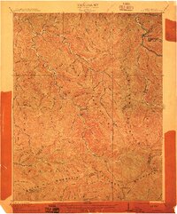
1912 Map of Bald Knob
USGS Topo · Published 1912About this map
The Cherry Pond Mountain and Guyandot Mountain ranges dominate this 1910 survey of southern West Virginia, capturing a landscape of steep hollows and winding coal-country drainages. Early rail infrastructure is visible along the C and O RR as it follows the Coal River and Marsh Fork, connecting the small riverbank communities of Whitesville and Jarrolds Valley. The map records the early development of the coalfields across the Boone, Logan, Raleigh, and Wyoming county lines, where family-named landmarks like Jarrolds Field and the Van settlement established the human footprint in the narrow valleys. Deep drainages such as Pond Fork and Spruce Fork carve through the high ridges, reaching toward Bald Knob and the isolated gap at Walnut Gap. This record provides an essential view of the region before the large-scale industrial shifts of the mid-20th century.
Find a feature on this map
91 named features on this map. Tap any name to fly to it.
Don’t see what you’re looking for? This feature index may not catch every label — zoom into the map to look around manually.
Map Details
Editions of this 1912 Bald Knob Map
3 editions found

Other maps of this area

1891 · Oceana
USGS Topo · 1:125,000

1891 · Raleigh
USGS Topo · 1:125,000

1893 · Oceana
USGS Topo · 1:125,000

1897 · Kanawha Falls
USGS Topo · 1:125,000

1897 · Raleigh
USGS Topo · 1:125,000

1898 · Oceana
USGS Topo · 1:125,000

1899 · Charleston
USGS Topo · 1:125,000

1900 · Kanawha Falls
USGS Topo · 1:125,000

1901 · Kanawha Falls
USGS Topo · 1:125,000

1902 · Raleigh
USGS Topo · 1:125,000