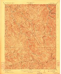
1912 Map of Bald Knob
USGS Topo · Published 1923About this map
Cook Mountain and Cherry Pond Mountain dominate this corner of the West Virginia coalfields, where the terrain is deeply dissected by numerous creeks and branches. Settlement is concentrated in the narrow valleys, with Whitesville and Van serving as primary hubs along the drainage of Pond Fork. The survey captures the industrial footprint of the early twentieth century, specifically the path of the C and O RR as it follows the waterways to reach timber and mineral resources. Genealogists may find value in the scattered local names such as Jarrells Valley and Jarrells Field, which suggest family landholdings in an era before large-scale industrial consolidation. The map also clearly delineates the complex county boundaries where Boone, Raleigh, Logan, and Wyoming Co meet at the ridgelines of Guyandot Mountain.
Find a feature on this map
69 named features on this map. Tap any name to fly to it.
Don’t see what you’re looking for? This feature index may not catch every label — zoom into the map to look around manually.
Map Details
Editions of this 1912 Bald Knob Map
3 editions found

Other maps of this area

1891 · Oceana
USGS Topo · 1:125,000

1891 · Raleigh
USGS Topo · 1:125,000

1893 · Oceana
USGS Topo · 1:125,000

1897 · Kanawha Falls
USGS Topo · 1:125,000

1897 · Raleigh
USGS Topo · 1:125,000

1898 · Oceana
USGS Topo · 1:125,000

1899 · Charleston
USGS Topo · 1:125,000

1900 · Kanawha Falls
USGS Topo · 1:125,000

1901 · Kanawha Falls
USGS Topo · 1:125,000

1902 · Raleigh
USGS Topo · 1:125,000