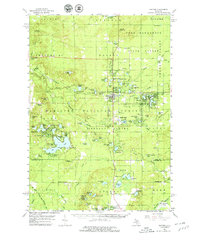
1959 Map of Baldwin
USGS Topo · Published 1979About this map
The Chesapeake and Ohio railroad corridor serves as the industrial and social spine of this Lake County landscape, connecting the regional center of Baldwin with the significant resort community at Idlewild. This mid-century survey illustrates a complex water network where the South Branch Pere Marquette River and its tributaries like Sweetwater Creek wind through the Pere Marquette State Forest. The map documents a transition from utilitarian land use, seen in numerous Gravel Pits and the Fish Hatchery, to a recreation-based economy centered around Idlewild Lake and Pine Grove Beach. Local history is anchored by rural institutions such as Dobry Sch and Riverside Sch, alongside several cemeteries including Webber Cem and Lake Cem. From the Ward Hill Lookout Tower to the Baldwin Landing Field, the map captures the organized infrastructure of the Manistee National Forest during a period of established seasonal tourism and forestry management.
Find a feature on this map
123 named features on this map. Tap any name to fly to it.
Don’t see what you’re looking for? This feature index may not catch every label — zoom into the map to look around manually.
Map Details
Editions of this 1959 Baldwin Map
4 editions found

Other maps of this area

1931 · Baldwin NW
USGS Topo · 1:31,680

1931 · Custer NE
USGS Topo · 1:31,680

1931 · Walkerville NE
USGS Topo · 1:31,680

1931 · Baldwin NE
USGS Topo · 1:31,680

1931 · Custer SE
USGS Topo · 1:31,680

1932 · Freesoil SE
USGS Topo · 1:31,680

1932 · Chase NW
USGS Topo · 1:31,680

1933 · Peacock SE
USGS Topo · 1:31,680

1933 · Peacock SW
USGS Topo · 1:31,680

1933 · Luther SW
USGS Topo · 1:31,680