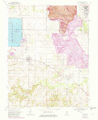
1970 Map of Baldwin
USGS Topo · Published 1982About this map
The boundary between St Clair Co and Randolph Co bisects a landscape defined by industrial expansion and agricultural roots in the early 1970s. The massive Strip Mine operations dominate the northeastern quadrant, where an Industrial Railroad and elevated conveyor systems connect the extraction sites to the regional infrastructure. This heavy industry contrasts with the preservation efforts at the Kaskaskia River State Fish and Wildlife Area, where the expansive Baldwin Lake serves both recreation and the nearby Powerplant.
Find a feature on this map
28 named features on this map. Tap any name to fly to it.
Don’t see what you’re looking for? This feature index may not catch every label — zoom into the map to look around manually.
Map Details
Editions of this 1970 Baldwin Map
2 editions found
Other maps of this area

1910 · Okawville
USGS Topo · 1:62,500

1912 · New Athens
USGS Topo · 1:62,500

1912 · Baldwin
USGS Topo · 1:62,500

1914 · Baldwin
USGS Topo · 1:62,500

1914 · Coulterville
USGS Topo · 1:62,500

1917 · Coulterville
USGS Topo · 1:62,500

1940 · Okawville
USGS Topo · 1:62,500

1942 · Baldwin
USGS Topo · 1:62,500

1954 · New Athens West
USGS Topo · 1:24,000
1954 · New Athens East
USGS Topo · 1:24,000