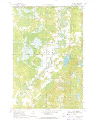
1970 Map of Ball Bluff
USGS Topo · Published 1972About this map
The Mississippi River winds through a heavily wooded and marshy landscape in this 1970 snapshot of Aitkin County, primarily defined by the Savanna State Forest. The river's serpentine path dominates the terrain, creating numerous oxbows and backwaters that separate the small settlements of Jacobson and Ball Bluff. This map illustrates the transition from river-bottom wetlands to the higher ground of the namesake Ball Bluff terrain feature.
Find a feature on this map
17 named features on this map. Tap any name to fly to it.
Don’t see what you’re looking for? This feature index may not catch every label — zoom into the map to look around manually.
Map Details
Editions of this 1970 Ball Bluff Map
2 editions found
Other maps of this area

1953 · Duluth
USGS Topo · 1:250,000

1954 · Hibbing
USGS Topo · 1:250,000

1957 · Hibbing
USGS Topo · 1:250,000

1958 · Hibbing
USGS Topo · 1:250,000

1958 · Duluth
USGS Topo · 1:250,000

1964 · Hibbing
USGS Topo · 1:250,000

1970 · Split Hand Lake
USGS Topo · 1:24,000

1970 · Rabey
USGS Topo · 1:24,000
1970 · Swan River
USGS Topo · 1:24,000

1970 · Sanders Lake
USGS Topo · 1:24,000