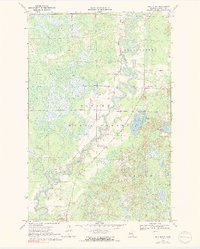
1970 Map of Ball Bluff
USGS Topo · Published 1991About this map
The Mississippi River creates a serpentine corridor through the center of this Aitkin County survey, carving deep oxbows and meanders through the wetlands of the Savanna State Forest. In the northeast, the settlement of Jacobson serves as a small population center near the river's edge, while the namesake Ball Bluff landmark rises as a distinct topographical feature to the south. This area is characterized by its complex hydrology, with numerous basins like Ball Bluff Lake, Blackface Lake, and Little Red Horse Lake dotting the landscape. A Senior Citizens Day Center and Ball Bluff Park provide localized community landmarks within the forest's boundaries, while a Gravel Pit indicates small-scale resource extraction from the glacial soils. The intricate patterns of the river's path, including Pokegama Creek, reflect a landscape that remains largely defined by its natural watercourses and timber land in the early 1970s.
Find a feature on this map
16 named features on this map. Tap any name to fly to it.
Don’t see what you’re looking for? This feature index may not catch every label — zoom into the map to look around manually.
Map Details
Editions of this 1970 Ball Bluff Map
2 editions found
Other maps of this area

1953 · Duluth
USGS Topo · 1:250,000

1954 · Hibbing
USGS Topo · 1:250,000

1957 · Hibbing
USGS Topo · 1:250,000

1958 · Hibbing
USGS Topo · 1:250,000

1958 · Duluth
USGS Topo · 1:250,000

1964 · Hibbing
USGS Topo · 1:250,000

1970 · Split Hand Lake
USGS Topo · 1:24,000

1970 · Rabey
USGS Topo · 1:24,000
1970 · Swan River
USGS Topo · 1:24,000

1970 · Sanders Lake
USGS Topo · 1:24,000