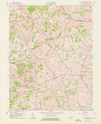
1961 Map of Ballardsville
USGS Topo · Published 1976About this map
The rolling drainage basins of Floyds Fork and Bullskin Creek dominate this 1960s landscape along the Oldham and Shelby County line. Small farming communities and crossroads such as Ballardsville and Chestnut Grove are connected by a network of winding roads like Hanna Road and Scotts Station Road. The agricultural character of the era is evident in the numerous family-named landmarks and local institutions, including Gleneyrie School and Fairview Church. Local topography is punctuated by prominent rises such as Gathright Hill and Lincolnfellow Hill, which overlook the various forks and runs that feed into the larger creek systems. These watercourses, including Little Bullskin Creek and Lick Run, helped dictate the placement of early settlements and road alignments across the central Kentucky bluegrass region.
Find a feature on this map
53 named features on this map. Tap any name to fly to it.
Don’t see what you’re looking for? This feature index may not catch every label — zoom into the map to look around manually.
Map Details
Editions of this 1961 Ballardsville Map
3 editions found
Other maps of this area

1923 · Waddy
USGS Topo · 1:48,000

1925 · Mount Eden
USGS Topo · 1:48,000

1927 · Mount Eden
USGS Topo · 1:62,500

1928 · New Castle
USGS Topo · 1:48,000

1929 · Taylorsville
USGS Topo · 1:62,500

1932 · New Castle
USGS Topo · 1:62,500

1932 · La Grange
USGS Topo · 1:62,500

1951 · Crestwood
USGS Topo · 1:24,000

1951 · Fisherville
USGS Topo · 1:24,000

1954 · Ballardsville
USGS Topo · 1:24,000