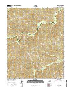
2016 Map of Ballsville
USGS Topo · Published 2016About this map
The Appomattox River winds through this central Virginia landscape, defining the border between Powhatan and Amelia Counties. In this agricultural region, the 2016 survey illustrates a pattern of small settlements and river-adjacent industries that have persisted over time. Clementown Mills stands as a focal point near Little Bent Cr, while the crossroads at Ballsville and Tobaccoville remain tied to the area's rural history. This map provides critical detail for family researchers tracing lineages in this part of the Piedmont, where the land is carved by numerous tributaries like Horsepen Cr and Flat Cr. Genealogists will find the exact placement of family burial grounds such as Piedmont Cem and Flower Hill Cem particularly valuable for locating ancestral home sites in the vicinity of Lodore and Haw Branch. The concentration of rural roads, including Genito Rd and Clementown Rd, highlights the connectivity of these dispersed farming communities.
Find a feature on this map
46 named features on this map. Tap any name to fly to it.
Don’t see what you’re looking for? This feature index may not catch every label — zoom into the map to look around manually.
Map Details
Editions of this 2016 Ballsville Map
This is the sole edition of this map. No revisions or reprints were ever made.
Other maps of this area

1890 · Goochland
USGS Topo · 1:125,000

1891 · Palmyra
USGS Topo · 1:125,000

1891 · Farmville
USGS Topo · 1:125,000

1892 · Goochland
USGS Topo · 1:125,000

1893 · Farmville
USGS Topo · 1:125,000

1895 · Palmyra
USGS Topo · 1:125,000

1897 · Amelia
USGS Topo · 1:125,000

1897 · Palmyra
USGS Topo · 1:125,000

1943 · Powhatan
USGS Topo · 1:31,680

1943 · Amelia
USGS Topo · 1:31,680