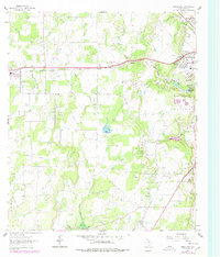
1962 Map of Bangs East
USGS Topo · Published 1978About this map
The Brownwood Oil Field and Childress Oil Field dominate this central Texas landscape, where derrick sites and gravel pits intermingle with rural homesteads and family cemeteries. In this early 1960s survey, the area west of Brownwood shows a transition from industrial activity to agricultural land, marked by the prominent Gulf Colorado and Santa Fe railroad line cutting through the northern section. Notable local landmarks include the Drive-in Theater and the Church of the Nazarene near the city's edge, while the southern reaches contain the vast Camp Bowie Military Reservation. The drainage patterns of Clear Creek and Adams Branch define the topography, which includes an Old Railroad Grade and several rural school sites like West Sch, providing researchers a detailed view of the infrastructure supporting both the petroleum industry and the local ranching community.
Find a feature on this map
31 named features on this map. Tap any name to fly to it.
Don’t see what you’re looking for? This feature index may not catch every label — zoom into the map to look around manually.
Map Details
Editions of this 1962 Bangs East Map
3 editions found
Other maps of this area

1887 · Coleman
USGS Topo · 1:125,000

1889 · Brownwood
USGS Topo · 1:125,000

1889 · Coleman
USGS Topo · 1:125,000

1894 · Brownwood
USGS Topo · 1:125,000

1924 · Brownwood Reservoir Site
USGS Topo · 1:48,000

1925 · Brownwood 3-b
USGS Topo · 1:48,000

1927 · Grosvenor
USGS Topo · 1:62,500

1928 · Zephyr
USGS Topo · 1:62,500

1950 · Zephyr
USGS Topo · 1:62,500

1954 · Brownwood
USGS Topo · 1:250,000