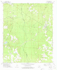
1973 Map of Banks
USGS Topo · Published 1975About this map
Moro Creek serves as a natural boundary dividing this timber and agriculture landscape between Calhoun and Bradley counties in the early 1970s. The settlement of Banks sits at a critical junction of the Chicago Rock Island and Pacific railroad and the Warren and Pacific Road, anchoring a rural network of small communities including Tinsman, Lanark, and Summerville. This survey captures the region's mid-century character, where dispersed homesteads are supported by local institutions like Pleasant Grove Church and Dickinson Church. Extensive gravel pits clustered near Jacks Creek suggest a localized extractive economy. Genealogists will find significant value in the documentation of family-named burial grounds, such as McFarland Cemetery, McLeod Cemetery, and Childs Cemetery, which remain key landmarks in this south-central Arkansas landscape.
Find a feature on this map
28 named features on this map. Tap any name to fly to it.
Don’t see what you’re looking for? This feature index may not catch every label — zoom into the map to look around manually.
Map Details
Editions of this 1973 Banks Map
2 editions found
Other maps of this area

1934 · Ingalls
USGS Topo · 1:48,000

1934 · Moro Bay
USGS Topo · 1:62,500

1937 · Ingalls
USGS Topo · 1:62,500

1938 · Moro Bay
USGS Topo · 1:62,500

1939 · Moro Bay
USGS Topo · 1:62,500

1939 · Ingalls
USGS Topo · 1:62,500

1953 · El Dorado
USGS Topo · 1:250,000

1957 · El Dorado
USGS Topo · 1:250,000

1958 · El Dorado
USGS Topo · 1:250,000

1960 · El Dorado
USGS Topo · 1:250,000