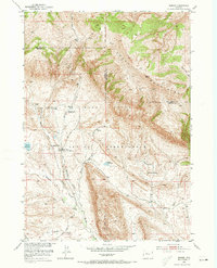
1952 Map of Bargee
USGS Topo · Published 1973About this map
The Wind River Indian Reservation landscape is defined by the high elevations of the Wind River Mountains and the strategic water sources that sustained early transport and settlement. A legacy of the frontier era is visible at Holland Place (Old Stage Station), marking a former stop on the overland routes. The map records a transition from high-country ranching to more formal administration, evidenced by the Muddy Creek Mail Camp Ranger Station and the Bargee School serving local ranching families. The complex hydrology of the region is traced through names like Bargee Creek, Warm Springs Creek, and Sagwup Creek, which flow through the high-desert terrain. Cattle operations like the Bargee Ranch and Bradford Ranch utilized these drainages, connected by specialized infrastructure such as the Dry Muddy Creek Mail Camp Road.
Find a feature on this map
21 named features on this map. Tap any name to fly to it.
Don’t see what you’re looking for? This feature index may not catch every label — zoom into the map to look around manually.
Map Details
Editions of this 1952 Bargee Map
3 editions found
Other maps of this area

1950 · Shotgun Butte
USGS Topo · 1:24,000

1951 · Eagle Point
USGS Topo · 1:24,000

1951 · Maverick Spring
USGS Topo · 1:24,000

1952 · Antelope Ridge
USGS Topo · 1:24,000

1952 · Sheep Ridge
USGS Topo · 1:24,000

1952 · Bargee
USGS Topo · 1:24,000

1955 · Thermopolis
USGS Topo · 1:250,000

1958 · Thermopolis
USGS Topo · 1:250,000

1962 · Thermopolis
USGS Topo · 1:250,000
1965 · Embar
USGS Topo · 1:24,000