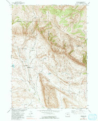
1952 Map of Bargee
USGS Topo · Published 1991About this map
The Wind River Indian Reservation landscape is defined by the high elevations of the Owl Creek Mountains and a network of remote homesteads and service points. Historical connectivity is anchored by Holland Place (Old Stage Station), which served travelers along early transit routes before the mid-20th century. The presence of the Bargee School and Bargee Ranch indicates a small but established community centered around the local drainage of Bargee Creek.
Find a feature on this map
23 named features on this map. Tap any name to fly to it.
Don’t see what you’re looking for? This feature index may not catch every label — zoom into the map to look around manually.
Map Details
Editions of this 1952 Bargee Map
3 editions found
Other maps of this area

1950 · Shotgun Butte
USGS Topo · 1:24,000

1951 · Eagle Point
USGS Topo · 1:24,000

1951 · Maverick Spring
USGS Topo · 1:24,000

1952 · Antelope Ridge
USGS Topo · 1:24,000

1952 · Sheep Ridge
USGS Topo · 1:24,000

1952 · Bargee
USGS Topo · 1:24,000

1955 · Thermopolis
USGS Topo · 1:250,000

1958 · Thermopolis
USGS Topo · 1:250,000

1962 · Thermopolis
USGS Topo · 1:250,000
1965 · Embar
USGS Topo · 1:24,000